

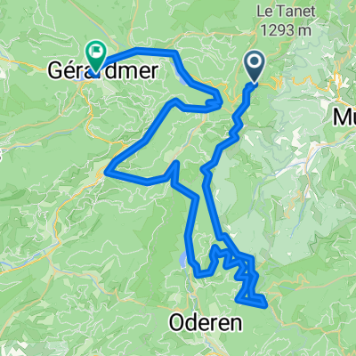
Col de la Schlucht<>Gerardmer
A cycling route starting in Soultzeren, Grand Est, France.
Overview
About this route
Route 4
- -:--
- Duration
- 78.3 km
- Distance
- 1,042 m
- Ascent
- 1,511 m
- Descent
- ---
- Avg. speed
- ---
- Max. altitude

Route quality
Waytypes & surfaces along the route
Waytypes
Road
30.5 km
(39 %)
Quiet road
0.8 km
(1 %)
Surfaces
Paved
50.1 km
(64 %)
Asphalt
50.1 km
(64 %)
Undefined
28.2 km
(36 %)
Continue with Bikemap
Use, edit, or download this cycling route
You would like to ride Col de la Schlucht<>Gerardmer or customize it for your own trip? Here is what you can do with this Bikemap route:
Free features
- Save this route as favorite or in collections
- Copy & plan your own version of this route
- Sync your route with Garmin or Wahoo
Premium features
Free trial for 3 days, or one-time payment. More about Bikemap Premium.
- Navigate this route on iOS & Android
- Export a GPX / KML file of this route
- Create your custom printout (try it for free)
- Download this route for offline navigation
Discover more Premium features.
Get Bikemap PremiumFrom our community
Other popular routes starting in Soultzeren
 Col de la Schlucht<>Gerardmer
- Distance
- 78.3 km
- Ascent
- 1,042 m
- Descent
- 1,511 m
- Location
- Soultzeren, Grand Est, France
 F_Vogesen-Felsenpfad-ColDeLaSchlucht_RR-6km-320hm
- Distance
- 5.9 km
- Ascent
- 454 m
- Descent
- 453 m
- Location
- Soultzeren, Grand Est, France
 2018 Grande and Petite Ballon (2) - hard
- Distance
- 114.9 km
- Ascent
- 2,183 m
- Descent
- 2,183 m
- Location
- Soultzeren, Grand Est, France
 Grande and Petite Ballon - moderately hard
- Distance
- 106 km
- Ascent
- 2,025 m
- Descent
- 2,027 m
- Location
- Soultzeren, Grand Est, France
 Zur 8. Etappe der TdF 2014
- Distance
- 14.2 km
- Ascent
- 299 m
- Descent
- 476 m
- Location
- Soultzeren, Grand Est, France
 Petit Ballon + Col de Platzerwasel (short)
- Distance
- 70.6 km
- Ascent
- 1,637 m
- Descent
- 1,616 m
- Location
- Soultzeren, Grand Est, France
 Schildmatt und Umgebung
- Distance
- 57.4 km
- Ascent
- 1,332 m
- Descent
- 1,332 m
- Location
- Soultzeren, Grand Est, France
 Hohneck ( Teilstück )
- Distance
- 24.4 km
- Ascent
- 964 m
- Descent
- 795 m
- Location
- Soultzeren, Grand Est, France
Open it in the app