

Großwaltersdorf-Flöha-Waldkirchen
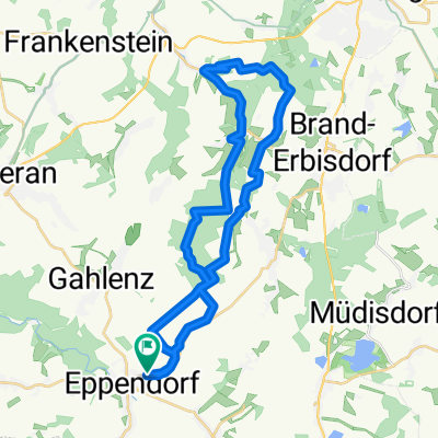
A cycling route starting in Eppendorf, Saxony, Germany.
Overview
About this route
Schöne Bergfahrten mit dabei, ansonsten auch flache Stücke. In Leubsdorf wird gerade gebaut. Ansonsten kann natürlich auch durch Leubsdorf gefahren werden.
->Dann ist es wirklich Rennradtauglich.
Größte Steigung ist um die 12%.
- -:--
- Duration
- 76.6 km
- Distance
- 1,125 m
- Ascent
- 1,127 m
- Descent
- ---
- Avg. speed
- 555 m
- Max. altitude
Route quality
Waytypes & surfaces along the route
Waytypes
Busy road
44.7 km
(58 %)
Road
14.3 km
(19 %)
Surfaces
Paved
67.8 km
(88 %)
Unpaved
3 km
(4 %)
Asphalt
66.9 km
(87 %)
Ground
2 km
(3 %)
Continue with Bikemap
Use, edit, or download this cycling route
You would like to ride Großwaltersdorf-Flöha-Waldkirchen or customize it for your own trip? Here is what you can do with this Bikemap route:
Free features
- Save this route as favorite or in collections
- Copy & plan your own version of this route
- Sync your route with Garmin or Wahoo
Premium features
Free trial for 3 days, or one-time payment. More about Bikemap Premium.
- Navigate this route on iOS & Android
- Export a GPX / KML file of this route
- Create your custom printout (try it for free)
- Download this route for offline navigation
Discover more Premium features.
Get Bikemap PremiumFrom our community
Other popular routes starting in Eppendorf
 Ulrike und zurück über Halbschranke
- Distance
- 16 km
- Ascent
- 220 m
- Descent
- 194 m
- Location
- Eppendorf, Saxony, Germany
 Eppendorf - Oberschöna Quarzitbruch
- Distance
- 32 km
- Ascent
- 436 m
- Descent
- 433 m
- Location
- Eppendorf, Saxony, Germany
 Eppendorf - Metzdorf - Runde
- Distance
- 33.7 km
- Ascent
- 458 m
- Descent
- 459 m
- Location
- Eppendorf, Saxony, Germany
 kleine Herausforderung
- Distance
- 32.3 km
- Ascent
- 559 m
- Descent
- 559 m
- Location
- Eppendorf, Saxony, Germany
 Feierabendrunde
- Distance
- 33.3 km
- Ascent
- 417 m
- Descent
- 417 m
- Location
- Eppendorf, Saxony, Germany
 Kleine "8"
- Distance
- 46.1 km
- Ascent
- 494 m
- Descent
- 526 m
- Location
- Eppendorf, Saxony, Germany
 Eppe-Bad Schandau über Hohe Tour
- Distance
- 129 km
- Ascent
- 1,225 m
- Descent
- 1,531 m
- Location
- Eppendorf, Saxony, Germany
 rund um den Schattenberg
- Distance
- 34.8 km
- Ascent
- 385 m
- Descent
- 386 m
- Location
- Eppendorf, Saxony, Germany
Open it in the app