
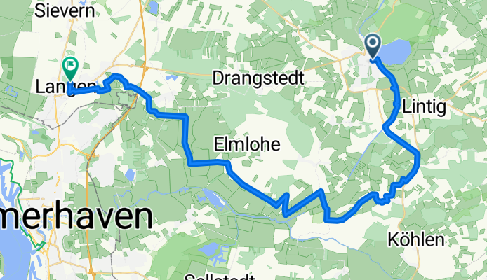
Bad Bederkesa-Langen 36 km
A cycling route starting in Lintig, Lower Saxony, Germany.
Overview
About this route
Vorschlag für Radtour im August 2009
(mit Tourenrad).
Varianten und Hinweise:
Auf dem ersten Streckenabschnitt bis zur Schleuse (ca. 3 km) sind teilweise unebene Wege (Verbundstein-Pflaster und feste Sandwege). Umgehungsmöglichkeit: Ankeloher Straße, rechts auf Radweg nach Lintig, rechts auf L116 nach Hainmühlen.
Rustikalerer dafür aber landschaftlich reizvollerer Streckenabschnitt: L128 bei km 5,5 rechts (Forsthaus Falle) durch den Wald, hinter der kleinen Brücke links und dann rechts nach Ringstedt.
In Ringstedt wird die sehr hollprige Schiebestrecke (Auf dem Felde) umfahren.
Vor der Kanalüberquerung und auf dem Kührstedter Damm teilweise grober Schotterweg. Der Kührstedter Damm kann dadurch umfahren werden, dass 2 Wege weiter links abgebogen wird (Richtung Flugplatz, Wasserwerk).<br />
Von Marschkamp durch's Wehdener Moor bis zur 2. Rechtsabzweigung teilweise grober Schotterweg.<br />
- -:--
- Duration
- 36.3 km
- Distance
- 79 m
- Ascent
- 74 m
- Descent
- ---
- Avg. speed
- 18 m
- Max. altitude
Route quality
Waytypes & surfaces along the route
Waytypes
Track
18.4 km
(51 %)
Quiet road
9.4 km
(26 %)
Surfaces
Paved
21.1 km
(58 %)
Unpaved
8.8 km
(24 %)
Asphalt
13 km
(36 %)
Gravel
8.8 km
(24 %)
Route highlights
Points of interest along the route
Point of interest after 3.1 km
Schleuse
Point of interest after 10.3 km
1. Pause, Kirche Ringstedt
Point of interest after 18.6 km
2. Pause, Bank Abzweigung Elmlohe
Point of interest after 30 km
Point of interest after 30 km
3. Pause (bei Bedarf) Waldwinkel
Point of interest after 30 km
3. Pause (bei Bedarf) Waldwinkel
Point of interest after 30 km
Continue with Bikemap
Use, edit, or download this cycling route
You would like to ride Bad Bederkesa-Langen 36 km or customize it for your own trip? Here is what you can do with this Bikemap route:
Free features
- Save this route as favorite or in collections
- Copy & plan your own version of this route
- Sync your route with Garmin or Wahoo
Premium features
Free trial for 3 days, or one-time payment. More about Bikemap Premium.
- Navigate this route on iOS & Android
- Export a GPX / KML file of this route
- Create your custom printout (try it for free)
- Download this route for offline navigation
Discover more Premium features.
Get Bikemap PremiumFrom our community
Other popular routes starting in Lintig
 dag3 Hamburg
- Distance
- 98 km
- Ascent
- 92 m
- Descent
- 94 m
- Location
- Lintig, Lower Saxony, Germany
 Herbstlaubtour
- Distance
- 44 km
- Ascent
- 93 m
- Descent
- 95 m
- Location
- Lintig, Lower Saxony, Germany
 N. 4. Bederkesa-Komp-Itzehoe
- Distance
- 75 km
- Ascent
- 5 m
- Descent
- 8 m
- Location
- Lintig, Lower Saxony, Germany
 Bad Bederkesa, Kollegentour 2020 Tag 1
- Distance
- 77.3 km
- Ascent
- 217 m
- Descent
- 214 m
- Location
- Lintig, Lower Saxony, Germany
 Meckelstedt--Holzurburg-Stinstedter See
- Distance
- 28 km
- Ascent
- 29 m
- Descent
- 33 m
- Location
- Lintig, Lower Saxony, Germany
 un den See 18
- Distance
- 17.3 km
- Ascent
- 8 m
- Descent
- 5 m
- Location
- Lintig, Lower Saxony, Germany
 Bederkesa
- Distance
- 9.8 km
- Ascent
- 23 m
- Descent
- 23 m
- Location
- Lintig, Lower Saxony, Germany
 Beers - Flögelner See - Beerster See
- Distance
- 28.5 km
- Ascent
- 22 m
- Descent
- 23 m
- Location
- Lintig, Lower Saxony, Germany
Open it in the app