

il percorso della pace
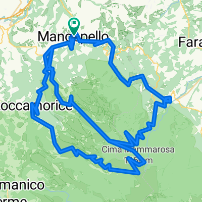
A cycling route starting in Manoppello, Abruzzo, Italy.
Overview
About this route
From San Giovanni to Volto Santo - May 2, 2014
Places along the path: Capestrano, Pietranico, Castiglione a Casauria, Torre dei Passeri, Piano d'Orta, Scafa, De Contra, Manoppello Distance: 47 km Description: From the Convent of San Giovanni da Capestrano, the route heads towards the fortified village of Pietranico, from which it descends into the valley to the Abbey of San Clemente a Casauria and then to the town of Torre dei Passeri. Passing through Piano d'Orta, it begins a gentle climb to the locality of Decontra where you can admire the splendid sulfur springs of the Lavino River Reserve. Then it continues to climb up to the Sanctuary of the Volto Santo in Manoppello.- -:--
- Duration
- 145.2 km
- Distance
- 1,212 m
- Ascent
- 1,374 m
- Descent
- ---
- Avg. speed
- ---
- Max. altitude
Route quality
Waytypes & surfaces along the route
Waytypes
Quiet road
42.1 km
(29 %)
Road
14.5 km
(10 %)
Surfaces
Paved
87.1 km
(60 %)
Unpaved
1.5 km
(1 %)
Asphalt
87.1 km
(60 %)
Ground
1.5 km
(1 %)
Undefined
56.6 km
(39 %)
Continue with Bikemap
Use, edit, or download this cycling route
You would like to ride il percorso della pace or customize it for your own trip? Here is what you can do with this Bikemap route:
Free features
- Save this route as favorite or in collections
- Copy & plan your own version of this route
- Split it into stages to create a multi-day tour
- Sync your route with Garmin or Wahoo
Premium features
Free trial for 3 days, or one-time payment. More about Bikemap Premium.
- Navigate this route on iOS & Android
- Export a GPX / KML file of this route
- Create your custom printout (try it for free)
- Download this route for offline navigation
Discover more Premium features.
Get Bikemap PremiumFrom our community
Other popular routes starting in Manoppello
 Manoppello to LettoManopello
- Distance
- 5.4 km
- Ascent
- 220 m
- Descent
- 102 m
- Location
- Manoppello, Abruzzo, Italy
 BlockHause
- Distance
- 54.8 km
- Ascent
- 1,745 m
- Descent
- 1,745 m
- Location
- Manoppello, Abruzzo, Italy
 Last 45 km Tireno adriatico stage 5
- Distance
- 44.9 km
- Ascent
- 1,515 m
- Descent
- 1,078 m
- Location
- Manoppello, Abruzzo, Italy
 Tappa 5 ultimi 47 km
- Distance
- 47.2 km
- Ascent
- 1,477 m
- Descent
- 1,170 m
- Location
- Manoppello, Abruzzo, Italy
 primo
primo- Distance
- 0.5 km
- Ascent
- 6 m
- Descent
- 9 m
- Location
- Manoppello, Abruzzo, Italy
 Passo Lanciano
- Distance
- 17.2 km
- Ascent
- 1,195 m
- Descent
- 31 m
- Location
- Manoppello, Abruzzo, Italy
 Da Via Brigata Maiella, Manoppello a Via Brigata Maiella, Manoppello
- Distance
- 90.9 km
- Ascent
- 3,187 m
- Descent
- 3,187 m
- Location
- Manoppello, Abruzzo, Italy
 3a tappa Manoppello - Blockhaus - Castel di Sangro
- Distance
- 133.1 km
- Ascent
- 3,207 m
- Descent
- 2,592 m
- Location
- Manoppello, Abruzzo, Italy
Open it in the app