
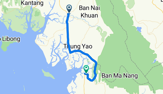
J36 - Yan Ta Khao - Thung Wa
A cycling route starting in Yan Ta Khao, Trang, Thailand.
Overview
About this route
J36 - Yan Ta Khao - Thung Wa - 54 kms - 13,65 kms / h - dénivelé montant 175 m - pente Maxi 5 %.
- -:--
- Duration
- 54.1 km
- Distance
- 152 m
- Ascent
- 148 m
- Descent
- ---
- Avg. speed
- ---
- Max. altitude
Route quality
Waytypes & surfaces along the route
Waytypes
Quiet road
6.5 km
(12 %)
Road
0.5 km
(1 %)
Surfaces
Paved
41.1 km
(76 %)
Asphalt
41.1 km
(76 %)
Undefined
13 km
(24 %)
Continue with Bikemap
Use, edit, or download this cycling route
You would like to ride J36 - Yan Ta Khao - Thung Wa or customize it for your own trip? Here is what you can do with this Bikemap route:
Free features
- Save this route as favorite or in collections
- Copy & plan your own version of this route
- Sync your route with Garmin or Wahoo
Premium features
Free trial for 3 days, or one-time payment. More about Bikemap Premium.
- Navigate this route on iOS & Android
- Export a GPX / KML file of this route
- Create your custom printout (try it for free)
- Download this route for offline navigation
Discover more Premium features.
Get Bikemap PremiumFrom our community
Other popular routes starting in Yan Ta Khao
 J36 - Yan Ta Khao - Thung Wa
- Distance
- 54.1 km
- Ascent
- 152 m
- Descent
- 148 m
- Location
- Yan Ta Khao, Trang, Thailand
 สพด-เจ้ทุด
- Distance
- 13.8 km
- Ascent
- 77 m
- Descent
- 74 m
- Location
- Yan Ta Khao, Trang, Thailand
 Yan Ta Khao - Khuan Kalong
- Distance
- 78.6 km
- Ascent
- 50 m
- Descent
- 0 m
- Location
- Yan Ta Khao, Trang, Thailand
 4261, ตำบล คลองชีล้อม to 4261, ตำบล คลองชีล้อม
- Distance
- 8.1 km
- Ascent
- 14 m
- Descent
- 17 m
- Location
- Yan Ta Khao, Trang, Thailand
Open it in the app