
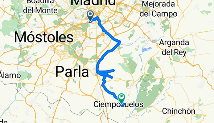
Orcasitas - Ciempozuelos
A cycling route starting in Villaverde, Madrid, Spain.
Overview
About this route
Route A-B. Return on RENFE
Route from Orcasitas via path (except for the first 10 km by bike lane and linear park Manzanares)
- -:--
- Duration
- 57.7 km
- Distance
- 221 m
- Ascent
- 285 m
- Descent
- ---
- Avg. speed
- ---
- Max. altitude

Route highlights
Points of interest along the route
Drinking water after 23.5 km
Gasolinera: Buen sitio para mirar la presión de las ruedas, en caso necesario y beber y comer algo.
Point of interest after 42.6 km
Salida hacia Renfe Pinto
Point of interest after 56.4 km
Posibilidad de hacer circular la ruta regresando por San Martín de la Vega
Continue with Bikemap
Use, edit, or download this cycling route
You would like to ride Orcasitas - Ciempozuelos or customize it for your own trip? Here is what you can do with this Bikemap route:
Free features
- Save this route as favorite or in collections
- Copy & plan your own version of this route
- Sync your route with Garmin or Wahoo
Premium features
Free trial for 3 days, or one-time payment. More about Bikemap Premium.
- Navigate this route on iOS & Android
- Export a GPX / KML file of this route
- Create your custom printout (try it for free)
- Download this route for offline navigation
Discover more Premium features.
Get Bikemap PremiumFrom our community
Other popular routes starting in Villaverde
 Orcasitas - Ciempozuelos
- Distance
- 57.7 km
- Ascent
- 221 m
- Descent
- 285 m
- Location
- Villaverde, Madrid, Spain
 PERALES DEL RIO-MADRID RIO.
- Distance
- 27.1 km
- Ascent
- 167 m
- Descent
- 148 m
- Location
- Villaverde, Madrid, Spain
 Orcasitas - Fuenlabrada (El Naranjo)
- Distance
- 41.3 km
- Ascent
- 146 m
- Descent
- 146 m
- Location
- Villaverde, Madrid, Spain
 Orcasitas - Ciempozuelos
- Distance
- 40.4 km
- Ascent
- 152 m
- Descent
- 225 m
- Location
- Villaverde, Madrid, Spain
 Ruta a la Casa de Campo por Venta La Rubia
- Distance
- 38.8 km
- Ascent
- 270 m
- Descent
- 264 m
- Location
- Villaverde, Madrid, Spain
 Circular Orcasitas-Cañada Real-Orcasitas
- Distance
- 28.5 km
- Ascent
- 96 m
- Descent
- 144 m
- Location
- Villaverde, Madrid, Spain
 Marañosa - Punto Geodésico
- Distance
- 47.5 km
- Ascent
- 189 m
- Descent
- 183 m
- Location
- Villaverde, Madrid, Spain
 Circular Orcasitas - Caminos cerca vías AVE
- Distance
- 32.7 km
- Ascent
- 138 m
- Descent
- 142 m
- Location
- Villaverde, Madrid, Spain
Open it in the app