
WOB Mörse-Flechtorf-Hondelage
A cycling route starting in Bevenrode, Lower Saxony, Germany.
Overview
About this route
Ride on 24.2.2014, 5-8°C, slightly damp ground, sunny, riding time approx. 2.5 - 3 hours
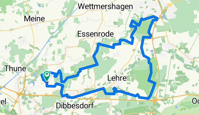
The route of 50 km and about 234 meters elevation starts from Waggum, passing through the forests near Wendhausen and Brunsrode into the forest before Wolfsburg Mörse. The return trip goes through the woodland near Flechtorf, the former munitions depot Munalehre, and via Lehre and its forests back to Waggum.
Almost exclusively upgraded forest and field paths are used, and some trail sections (approx. 7 km), which at Brunsrode include a carry section over a ditch (a temporary bridge was built on the day of the ride). On this ride, only the places Flechtorf and Hondelage are passed through; asphalt is minimal. This ride is well suited for exploring the Braunschweig surroundings in bad weather. The nicest trail starts at kilometer 24 near Wob-Heinekamp, about 1.4 km with small ditch crossings, slightly uphill. It may make sense to do the route in reverse because the nice trail at Heinenkamp can be ridden downhill, and the crossing to the stream at Brunsrode is easier to find. The disadvantage at the stream crossing: if the crossing is washed away, you need to jump over the ditch (over 1.5 m wide), as there is no material there for a new bridge.
Have fun riding down; some adventure included.
- -:--
- Duration
- 50.2 km
- Distance
- 224 m
- Ascent
- 225 m
- Descent
- ---
- Avg. speed
- ---
- Max. altitude

Route quality
Waytypes & surfaces along the route
Waytypes
Track
36.7 km
(73 %)
Path
7 km
(14 %)
Surfaces
Paved
8.5 km
(17 %)
Unpaved
38.7 km
(77 %)
Gravel
13.6 km
(27 %)
Loose gravel
12.6 km
(25 %)
Route highlights
Points of interest along the route
Point of interest after 0.9 km
Singletrail hinauf zu Firma Kolbe
Point of interest after 3.1 km
Trailabschnitt durch den Forst bei Bevenrode, ca. 1,2 km lang
Point of interest after 7.5 km
Bank zum Pausieren, schöner Blick Richtung Wendhausen
Point of interest after 9.8 km
Biotop mit mehreren Teichen
Point of interest after 12.6 km
Trailabschnit und Wiesenwaldweg bei Essenrode
Point of interest after 14.3 km
Wiesenweg z.T. schwerer Boden
Point of interest after 17.7 km
Trail bei Brunsrode ca. 1,3 km lang
Point of interest after 18.8 km
zwei Trailabschnitt, mit z.T. Wasserdurchfahrten etwas schwieriger zu befahren, ca.350m
Point of interest after 19.2 km
Trail endet hier, muss man dem Track folgen ca.100m, bischen intuitiv
Point of interest after 19.4 km
Grabenübergang, ca. 1,50m breit, am Feb 2014 Behelfsbrücke gebaut
Point of interest after 21 km
Tail ca. 750m mit mehreren kleinen Matschdurchfahrten
Point of interest after 21.7 km
Trailkurs, mit Trichterdurchfahrten, Rampen u. Anlegerspuren
Point of interest after 21.8 km
kurzer Trailabschnitt, ca. 150m
Point of interest after 24.5 km
super Singletrail, leicht bergauf mit meheren kurzen Grabendurchfahrten mit Behelfsbrücken; ca.1,4 km, in anderer Richtung schöner zu fahren
Point of interest after 38.7 km
Singletrail bei Lehre, ca. 600m
Point of interest after 39.2 km
zweiter Singletrailabschnitt, ca.300m
Point of interest after 43.3 km
Bachfurt
Point of interest after 43.6 km
Singletrail an der Schunter
Point of interest after 45.3 km
Singletrail parallel zur A2, im hinteren Drittel kurviges Bergabstück
Point of interest after 46.8 km
Singletrail, ca. 400m, oft schwerer Boden mit matschigen Passagen
Point of interest after 48.5 km
Singletrail zur Landebahn und parallel zum Zaun
Continue with Bikemap
Use, edit, or download this cycling route
You would like to ride WOB Mörse-Flechtorf-Hondelage or customize it for your own trip? Here is what you can do with this Bikemap route:
Free features
- Save this route as favorite or in collections
- Copy & plan your own version of this route
- Sync your route with Garmin or Wahoo
Premium features
Free trial for 3 days, or one-time payment. More about Bikemap Premium.
- Navigate this route on iOS & Android
- Export a GPX / KML file of this route
- Create your custom printout (try it for free)
- Download this route for offline navigation
Discover more Premium features.
Get Bikemap PremiumFrom our community
Other popular routes starting in Bevenrode
 BS-West BS-Ost
- Distance
- 69.1 km
- Ascent
- 102 m
- Descent
- 89 m
- Location
- Bevenrode, Lower Saxony, Germany
 Ruta relajada en essenrode
- Distance
- 13.4 km
- Ascent
- 101 m
- Descent
- 133 m
- Location
- Bevenrode, Lower Saxony, Germany
 2025.04.24 - Dibbesdorf-Riddagshausen-Oker-Stadion-Querum-Dibbesdorf
- Distance
- 22.5 km
- Ascent
- 44 m
- Descent
- 45 m
- Location
- Bevenrode, Lower Saxony, Germany
 WOB Mörse-Flechtorf-Hondelage
- Distance
- 50.2 km
- Ascent
- 224 m
- Descent
- 225 m
- Location
- Bevenrode, Lower Saxony, Germany
 Erweiterung der schattigen Waldtour - Braunschweig Nordost
- Distance
- 19.7 km
- Ascent
- 77 m
- Descent
- 95 m
- Location
- Bevenrode, Lower Saxony, Germany
 2025.05.08 - Dibbesdorf-Thune Spargelhof-Dalmacija-Wenden-Rühme-Querum-Dibbesdorf
- Distance
- 26.6 km
- Ascent
- 63 m
- Descent
- 64 m
- Location
- Bevenrode, Lower Saxony, Germany
 Südsee-Funkturm-Millenium Berg
- Distance
- 57.2 km
- Ascent
- 118 m
- Descent
- 118 m
- Location
- Bevenrode, Lower Saxony, Germany
 2025.05.22 - Dibbesdorf-Gliesmarode-Ringgleis-Riddagshausen-Dibbesdorf
- Distance
- 30.2 km
- Ascent
- 68 m
- Descent
- 69 m
- Location
- Bevenrode, Lower Saxony, Germany
Open it in the app