

Japan 1
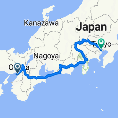
A cycling route starting in Sakai, Osaka, Japan.
Overview
About this route
/
- -:--
- Duration
- 1,418.5 km
- Distance
- 1,798 m
- Ascent
- 1,733 m
- Descent
- ---
- Avg. speed
- ---
- Max. altitude
Continue with Bikemap
Use, edit, or download this cycling route
You would like to ride Japan 1 or customize it for your own trip? Here is what you can do with this Bikemap route:
Free features
- Save this route as favorite or in collections
- Copy & plan your own version of this route
- Split it into stages to create a multi-day tour
- Sync your route with Garmin or Wahoo
Premium features
Free trial for 3 days, or one-time payment. More about Bikemap Premium.
- Navigate this route on iOS & Android
- Export a GPX / KML file of this route
- Create your custom printout (try it for free)
- Download this route for offline navigation
Discover more Premium features.
Get Bikemap PremiumFrom our community
Other popular routes starting in Sakai
 紐解けば堺 サンプルルート
- Distance
- 10.4 km
- Ascent
- 60 m
- Descent
- 70 m
- Location
- Sakai, Osaka, Japan
 環濠クルーズコース
- Distance
- 7.4 km
- Ascent
- 5 m
- Descent
- 15 m
- Location
- Sakai, Osaka, Japan
 Osaka Nara Loop from Hotel
- Distance
- 83.8 km
- Ascent
- 1,235 m
- Descent
- 1,229 m
- Location
- Sakai, Osaka, Japan
 japan
japan- Distance
- 975 km
- Ascent
- 5,309 m
- Descent
- 5,294 m
- Location
- Sakai, Osaka, Japan
 factorism cycling: route B
- Distance
- 12 km
- Ascent
- 44 m
- Descent
- 55 m
- Location
- Sakai, Osaka, Japan
 渡船場―夢洲ルート
- Distance
- 41.1 km
- Ascent
- 143 m
- Descent
- 148 m
- Location
- Sakai, Osaka, Japan
 大山公園「伸庵」呈茶コース
- Distance
- 8.5 km
- Ascent
- 34 m
- Descent
- 42 m
- Location
- Sakai, Osaka, Japan
 アパ堺→長居
- Distance
- 8.1 km
- Ascent
- 25 m
- Descent
- 24 m
- Location
- Sakai, Osaka, Japan
Open it in the app