

Linha Tormen 1
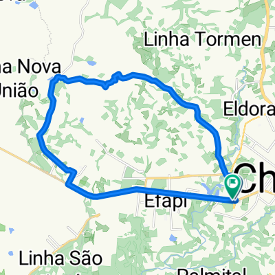
A cycling route starting in Chapecó, Santa Catarina, Brazil.
Overview
About this route
Moderate route. Mixed, dirt and asphalt.
- -:--
- Duration
- 18.6 km
- Distance
- 284 m
- Ascent
- 287 m
- Descent
- ---
- Avg. speed
- ---
- Max. altitude

Continue with Bikemap
Use, edit, or download this cycling route
You would like to ride Linha Tormen 1 or customize it for your own trip? Here is what you can do with this Bikemap route:
Free features
- Save this route as favorite or in collections
- Copy & plan your own version of this route
- Sync your route with Garmin or Wahoo
Premium features
Free trial for 3 days, or one-time payment. More about Bikemap Premium.
- Navigate this route on iOS & Android
- Export a GPX / KML file of this route
- Create your custom printout (try it for free)
- Download this route for offline navigation
Discover more Premium features.
Get Bikemap PremiumFrom our community
Other popular routes starting in Chapecó
 Caxambu Ida e Volta
- Distance
- 74.8 km
- Ascent
- 765 m
- Descent
- 772 m
- Location
- Chapecó, Santa Catarina, Brazil
 De Rua Genir José Destri 165 a SC-157
- Distance
- 6.1 km
- Ascent
- 70 m
- Descent
- 0 m
- Location
- Chapecó, Santa Catarina, Brazil
 De Rua Osvaldo Cruz a Rua Osvaldo Cruz
- Distance
- 10.2 km
- Ascent
- 80 m
- Descent
- 88 m
- Location
- Chapecó, Santa Catarina, Brazil
 getulio+marvel+leopoldo
- Distance
- 25.1 km
- Ascent
- 339 m
- Descent
- 339 m
- Location
- Chapecó, Santa Catarina, Brazil
 Passeio rápido em Brasil
- Distance
- 26.4 km
- Ascent
- 455 m
- Descent
- 456 m
- Location
- Chapecó, Santa Catarina, Brazil
 Linha Tormen 1
- Distance
- 18.6 km
- Ascent
- 284 m
- Descent
- 287 m
- Location
- Chapecó, Santa Catarina, Brazil
 Rota 01 Set. 25 (noturna)
- Distance
- 12.6 km
- Ascent
- 133 m
- Descent
- 142 m
- Location
- Chapecó, Santa Catarina, Brazil
 Sitio Pousada
- Distance
- 23.9 km
- Ascent
- 443 m
- Descent
- 449 m
- Location
- Chapecó, Santa Catarina, Brazil
Open it in the app