

Dunc Gray Velodrome to Prospect Dam via Orphan School Creek
A cycling route starting in Regents Park, New South Wales, Australia.
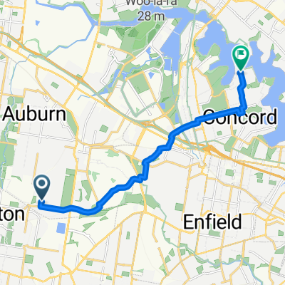
Overview
About this route
Uses off-road shared cycle paths entirely. Includes diversion to Wetherill Park McDonalds McCafe for morning coffee. Hills at Lansdowne are steep (>10%) but short. Hills froom Abbotsbury to Prospect Dam are steep and longer - difficult for unfit riders. Otherwise mostly flat.
Note that Prospect Canal Cycleway is blocked for construction work just east of Prospect Dam until Oct 2009 (and probably later)
Track Length 32.05km Passing Thru: Bass Hill, Georges Hall, Lansdowne, Carramar, Canley Vale, Canley Heights, Wakeley, Prairiewood, Wetherill Park, Greenfield Park, Bossley Park, Edensor Park, Abbotsbury, Horsley Park, Pemulwuy.
- -:--
- Duration
- 31 km
- Distance
- 156 m
- Ascent
- 126 m
- Descent
- ---
- Avg. speed
- 88 m
- Max. altitude
Route quality
Waytypes & surfaces along the route
Waytypes
Cycleway
24.3 km
(78 %)
Access road
2.5 km
(8 %)
Surfaces
Paved
30.5 km
(98 %)
Unpaved
0 km
(<1 %)
Concrete
19.8 km
(64 %)
Asphalt
6.1 km
(20 %)
Route highlights
Points of interest along the route
Point of interest after 24.1 km
Toilets, Water, BBQ and picnic facilities.
Point of interest after 26.2 km
Turn left uphill here on Southern Side of traffic light crossing, cross lights at Ferrers Rd and continue along northern side of The Horsley Drive to link up with M7 Cycleway at Horsley Park.
Continue with Bikemap
Use, edit, or download this cycling route
You would like to ride Dunc Gray Velodrome to Prospect Dam via Orphan School Creek or customize it for your own trip? Here is what you can do with this Bikemap route:
Free features
- Save this route as favorite or in collections
- Copy & plan your own version of this route
- Sync your route with Garmin or Wahoo
Premium features
Free trial for 3 days, or one-time payment. More about Bikemap Premium.
- Navigate this route on iOS & Android
- Export a GPX / KML file of this route
- Create your custom printout (try it for free)
- Download this route for offline navigation
Discover more Premium features.
Get Bikemap PremiumFrom our community
Other popular routes starting in Regents Park
 1 Johnston Rd, Bass Hill to 83 Milperra Rd, Revesby
- Distance
- 5.7 km
- Ascent
- 37 m
- Descent
- 61 m
- Location
- Regents Park, New South Wales, Australia
 Regents Park to KCCS Arncliffe via Cooks River Cycleway
- Distance
- 18.4 km
- Ascent
- 102 m
- Descent
- 113 m
- Location
- Regents Park, New South Wales, Australia
 Dunc Gray Velodrome to Silverwater Bridge
- Distance
- 22.1 km
- Ascent
- 77 m
- Descent
- 115 m
- Location
- Regents Park, New South Wales, Australia
 Dunc Gray Velodrome to Prospect Dam
- Distance
- 42.9 km
- Ascent
- 163 m
- Descent
- 170 m
- Location
- Regents Park, New South Wales, Australia
 Regents Park to KCCS Arncliffe via Cooks River Cycleway
- Distance
- 18.4 km
- Ascent
- 110 m
- Descent
- 118 m
- Location
- Regents Park, New South Wales, Australia
 66 Wyatt Avenue, Regents Park to 18 Woodlands Avenue, Breakfast Point
- Distance
- 6,050.5 km
- Ascent
- 113 m
- Descent
- 152 m
- Location
- Regents Park, New South Wales, Australia
 9 Patricia St, Chester Hill to 9 Patricia St, Chester Hill
- Distance
- 4.1 km
- Ascent
- 27 m
- Descent
- 22 m
- Location
- Regents Park, New South Wales, Australia
 Dunc Gray Velodrome to Rhodes via Liverpool Rail Trail
- Distance
- 68.1 km
- Ascent
- 130 m
- Descent
- 130 m
- Location
- Regents Park, New South Wales, Australia
Open it in the app