

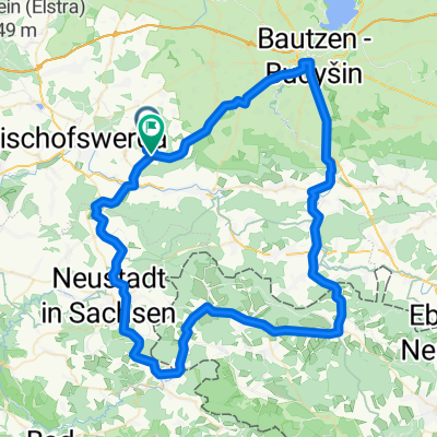
Radeberg-Stolpen-Putzkau
A cycling route starting in Demitz-Thumitz, Saxony, Germany.
Overview
About this route
good for racing bike beginners curvy and hilly sections unfortunately, at the exit of Großröhrsdorf there is bridge construction, making the road a bit bumpy
- -:--
- Duration
- 63.8 km
- Distance
- 442 m
- Ascent
- 403 m
- Descent
- ---
- Avg. speed
- 398 m
- Max. altitude

Route quality
Waytypes & surfaces along the route
Waytypes
Road
12.8 km
(20 %)
Quiet road
5.7 km
(9 %)
Surfaces
Paved
56.1 km
(88 %)
Unpaved
1.9 km
(3 %)
Asphalt
55.5 km
(87 %)
Gravel
1.3 km
(2 %)
Route highlights
Points of interest along the route
Point of interest after 62.3 km
Start
Point of interest after 62.4 km
Continue with Bikemap
Use, edit, or download this cycling route
You would like to ride Radeberg-Stolpen-Putzkau or customize it for your own trip? Here is what you can do with this Bikemap route:
Free features
- Save this route as favorite or in collections
- Copy & plan your own version of this route
- Sync your route with Garmin or Wahoo
Premium features
Free trial for 3 days, or one-time payment. More about Bikemap Premium.
- Navigate this route on iOS & Android
- Export a GPX / KML file of this route
- Create your custom printout (try it for free)
- Download this route for offline navigation
Discover more Premium features.
Get Bikemap PremiumFrom our community
Other popular routes starting in Demitz-Thumitz
 Radeberg-Stolpen-Putzkau
- Distance
- 63.8 km
- Ascent
- 442 m
- Descent
- 403 m
- Location
- Demitz-Thumitz, Saxony, Germany
 Bastei-Hohnstein-Sebnitz-
- Distance
- 77.3 km
- Ascent
- 878 m
- Descent
- 866 m
- Location
- Demitz-Thumitz, Saxony, Germany
 Putzkau-Oberlausitz
- Distance
- 37.2 km
- Ascent
- 225 m
- Descent
- 226 m
- Location
- Demitz-Thumitz, Saxony, Germany
 Trainingsrunde Schmölln-Neustadt
- Distance
- 34.4 km
- Ascent
- 314 m
- Descent
- 305 m
- Location
- Demitz-Thumitz, Saxony, Germany
 MTB 2300 Hm "Oberlausitzer Kammtour"
- Distance
- 67.1 km
- Ascent
- 1,409 m
- Descent
- 1,409 m
- Location
- Demitz-Thumitz, Saxony, Germany
 MTB 2300 Hm "Oberlausitzer Kammtour"
- Distance
- 67.1 km
- Ascent
- 1,363 m
- Descent
- 1,363 m
- Location
- Demitz-Thumitz, Saxony, Germany
 Dresdener Straße 4, Demitz-Thumitz Bautzen Frenzel Bräu nach Dresdener Straße 4, Demitz-Thumitz
- Distance
- 40.4 km
- Ascent
- 542 m
- Descent
- 518 m
- Location
- Demitz-Thumitz, Saxony, Germany
 Neuschmölln-Bautzen-Sohland-Sebnitz-Neuschmölln
- Distance
- 80 km
- Ascent
- 833 m
- Descent
- 839 m
- Location
- Demitz-Thumitz, Saxony, Germany
Open it in the app