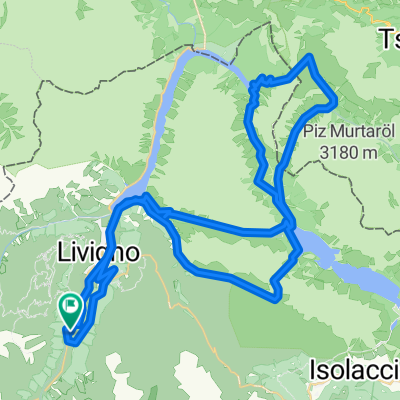
Livigno - Passo del Gallo
A cycling route starting in Livigno, Lombardy, Italy.
Overview
About this route
jako jo!
- -:--
- Duration
- 65.7 km
- Distance
- 1,621 m
- Ascent
- 1,621 m
- Descent
- ---
- Avg. speed
- ---
- Max. altitude
Route highlights
Points of interest along the route
Point of interest after 18.7 km
water spring
Point of interest after 23.4 km
lavka
Point of interest after 36.4 km
stone bridge
Point of interest after 45.7 km
knajpa
Point of interest after 52.5 km
wooden bridge
Continue with Bikemap
Use, edit, or download this cycling route
You would like to ride Livigno - Passo del Gallo or customize it for your own trip? Here is what you can do with this Bikemap route:
Free features
- Save this route as favorite or in collections
- Copy & plan your own version of this route
- Sync your route with Garmin or Wahoo
Premium features
Free trial for 3 days, or one-time payment. More about Bikemap Premium.
- Navigate this route on iOS & Android
- Export a GPX / KML file of this route
- Create your custom printout (try it for free)
- Download this route for offline navigation
Discover more Premium features.
Get Bikemap PremiumFrom our community
Other popular routes starting in Livigno
 Giro delle tee
- Distance
- 22.3 km
- Ascent
- 384 m
- Descent
- 386 m
- Location
- Livigno, Lombardy, Italy
 Livigno - Passo del Gallo
- Distance
- 65.7 km
- Ascent
- 1,621 m
- Descent
- 1,621 m
- Location
- Livigno, Lombardy, Italy
 Livigno - S.ta Maria (TorTour 2008 - 1)
- Distance
- 45.4 km
- Ascent
- 1,233 m
- Descent
- 1,679 m
- Location
- Livigno, Lombardy, Italy
 Livigno camp - Pass Forcola di Livigno - Pass da Val Viola - Passo della Vallacia - Passo d`Eira - singl do Val delle Mine
- Distance
- 63.7 km
- Ascent
- 2,061 m
- Descent
- 2,079 m
- Location
- Livigno, Lombardy, Italy
 Livigno, Mottolino (mit der Bahn), Passo d'Eira, Ponte del Rez, Passo di Foscagno, Valle di FoscagnTorn di Fraele, Rifugio Monte Scale Park, Valle Alpisella, Li
- Distance
- 43 km
- Ascent
- 932 m
- Descent
- 1,472 m
- Location
- Livigno, Lombardy, Italy
 Alpisella Val Tort
- Distance
- 35.9 km
- Ascent
- 989 m
- Descent
- 989 m
- Location
- Livigno, Lombardy, Italy
 livigno stelvio
- Distance
- 54.9 km
- Ascent
- 2,108 m
- Descent
- 1,178 m
- Location
- Livigno, Lombardy, Italy
 Livigno - Mottolino Flow Trail
- Distance
- 25 km
- Ascent
- 823 m
- Descent
- 823 m
- Location
- Livigno, Lombardy, Italy
Open it in the app


