

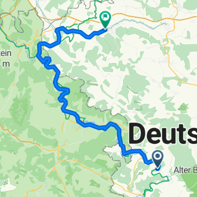
Noch eine Runde mit einem Berg
A cycling route starting in Frankenroda, Thuringia, Germany.
Overview
About this route
- -:--
- Duration
- 34 km
- Distance
- 509 m
- Ascent
- 512 m
- Descent
- ---
- Avg. speed
- 440 m
- Max. altitude
Route quality
Waytypes & surfaces along the route
Waytypes
Road
8.8 km
(26 %)
Quiet road
7.1 km
(21 %)
Surfaces
Paved
14.9 km
(44 %)
Unpaved
0.3 km
(1 %)
Asphalt
14.6 km
(43 %)
Paved (undefined)
0.3 km
(1 %)
Route highlights
Points of interest along the route
Point of interest after 21.6 km
Achtung! 2 km Kopfsteinpflaster. Paris-Roubaix lässt Grüßen!
Continue with Bikemap
Use, edit, or download this cycling route
You would like to ride Noch eine Runde mit einem Berg or customize it for your own trip? Here is what you can do with this Bikemap route:
Free features
- Save this route as favorite or in collections
- Copy & plan your own version of this route
- Sync your route with Garmin or Wahoo
Premium features
Free trial for 3 days, or one-time payment. More about Bikemap Premium.
- Navigate this route on iOS & Android
- Export a GPX / KML file of this route
- Create your custom printout (try it for free)
- Download this route for offline navigation
Discover more Premium features.
Get Bikemap PremiumFrom our community
Other popular routes starting in Frankenroda
 Falken, Treffurt, Eschwege
- Distance
- 28.5 km
- Ascent
- 262 m
- Descent
- 263 m
- Location
- Frankenroda, Thuringia, Germany
 Flache Runde mit der Möglichkeit einen Abstecher nach Scherbda zu machen
- Distance
- 44.1 km
- Ascent
- 311 m
- Descent
- 311 m
- Location
- Frankenroda, Thuringia, Germany
 Frankenroda - Heilbad Heiligenstadt
- Distance
- 80.6 km
- Ascent
- 92 m
- Descent
- 37 m
- Location
- Frankenroda, Thuringia, Germany
 Fietsvakantie 2017, dag 3
- Distance
- 76.3 km
- Ascent
- 271 m
- Descent
- 219 m
- Location
- Frankenroda, Thuringia, Germany
 Vom Teutoburger Wald zum Fichtelgebirge Etappe 4
- Distance
- 89.3 km
- Ascent
- 380 m
- Descent
- 324 m
- Location
- Frankenroda, Thuringia, Germany
 Werra nach Erfurt über den Kindel
- Distance
- 75.8 km
- Ascent
- 421 m
- Descent
- 344 m
- Location
- Frankenroda, Thuringia, Germany
 Noch eine Runde mit einem Berg
- Distance
- 34 km
- Ascent
- 509 m
- Descent
- 512 m
- Location
- Frankenroda, Thuringia, Germany
 4. Etappe Werratalradweg (Hann.-Münden)
- Distance
- 86.4 km
- Ascent
- 255 m
- Descent
- 306 m
- Location
- Frankenroda, Thuringia, Germany
Open it in the app