

Radtour von Berggießhübel zur Grenzplatte
A cycling route starting in Dohma, Saxony, Germany.
Overview
About this route
Route:
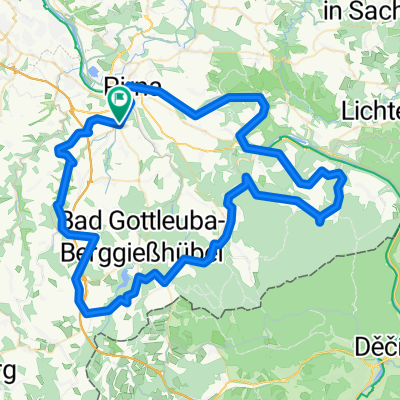
Berggießhübel - Bahra - Grenzplatte - Hellendorf - Bad Gottleuba - Berggießhübel Route length: approx. 30 km Route description: From the car park at the Marie-Louise-Stolln visitor mine in Berggießhübel, cycle downhill and cross the Eisenstraße. This road was formerly used as a transport route for the iron ore mines in the Gottleuba valley to the hammer mills on the banks of the Bahra river. Soon you reach the town of the same name; after a longer, steady climb you pass through the small village of Raum. From there, surrounded by the foothills of the Elbsandsteingebirge, after about 6 km you reach the Grenzplatte. From this romantic rock formation you get a fantastic view of the popular climbing area in the Bielatal. Then you cycle along the border with the Czech Republic through a large stand of spruce trees and from the approximately 550 m high Zeisigstein you can enjoy the view over the mountain meadows of the Osterzgebirge. From here it is only a few minutes by bike to the Bahra valley. Afterwards you return to your starting point in Berggießhübel via Hellendorf and Bad Gottleuba. Difficulty: The tour runs mostly on flat terrain. Smaller climbs are on the Eisenstraße, from Bahra towards Raum, and in the rear Schaftwald towards the Grenzplatte. A slightly steeper climb is the approximately 1.5 km section from Hellendorf towards Bad Gottleuba, which can alternatively be avoided by taking a ride through the Bahra valley via Markersbach and Bahra back to Berggießhübel. Bike rental: Parkhotel 'Sächsisches Haus' Sebastian-Kneipp-Str. 11 01819 Kurort Berggießhübel Phone: 035023 630 www.hotel-saechsisches-haus.de/e-bike-verleih In addition to regular touring bikes, e-bikes can also be rented here. Contact: Tourist Information Berggießhübel Siedlung 1 01819 Berggießhübel Phone: 035023 52980 www.badgottleuba-berggiesshuebel.de- -:--
- Duration
- 30.8 km
- Distance
- 499 m
- Ascent
- 499 m
- Descent
- ---
- Avg. speed
- ---
- Max. altitude
Route quality
Waytypes & surfaces along the route
Waytypes
Track
16 km
(52 %)
Quiet road
3.4 km
(11 %)
Surfaces
Paved
16 km
(52 %)
Unpaved
8.9 km
(29 %)
Asphalt
13.8 km
(45 %)
Gravel
3.4 km
(11 %)
Route highlights
Points of interest along the route
Point of interest after 30.6 km
Toursitinformation & Besucherbergwerk "Marie-Louise-Stolln" Mehr Informationen: www.marie-louise-stolln.de Telefon: 035023 52980
Continue with Bikemap
Use, edit, or download this cycling route
You would like to ride Radtour von Berggießhübel zur Grenzplatte or customize it for your own trip? Here is what you can do with this Bikemap route:
Free features
- Save this route as favorite or in collections
- Copy & plan your own version of this route
- Sync your route with Garmin or Wahoo
Premium features
Free trial for 3 days, or one-time payment. More about Bikemap Premium.
- Navigate this route on iOS & Android
- Export a GPX / KML file of this route
- Create your custom printout (try it for free)
- Download this route for offline navigation
Discover more Premium features.
Get Bikemap PremiumFrom our community
Other popular routes starting in Dohma
 Osterzgebirge
- Distance
- 62 km
- Ascent
- 674 m
- Descent
- 671 m
- Location
- Dohma, Saxony, Germany
 Talsperre Hartmannsbach
- Distance
- 14.8 km
- Ascent
- 247 m
- Descent
- 245 m
- Location
- Dohma, Saxony, Germany
 Berggießhübel-Gersdorf-Gottleuba-Bergg
- Distance
- 19.3 km
- Ascent
- 349 m
- Descent
- 350 m
- Location
- Dohma, Saxony, Germany
 Die Entspannungstour zum Feierabend
- Distance
- 15.3 km
- Ascent
- 271 m
- Descent
- 271 m
- Location
- Dohma, Saxony, Germany
 Entspannungsrunde
- Distance
- 16.5 km
- Ascent
- 295 m
- Descent
- 290 m
- Location
- Dohma, Saxony, Germany
 Burgenland ab Pirna
- Distance
- 89.5 km
- Ascent
- 1,037 m
- Descent
- 1,037 m
- Location
- Dohma, Saxony, Germany
 Radtour von Berggießhübel zur Grenzplatte
- Distance
- 30.8 km
- Ascent
- 499 m
- Descent
- 499 m
- Location
- Dohma, Saxony, Germany
 Bahra/Liebenau
- Distance
- 21.7 km
- Ascent
- 419 m
- Descent
- 182 m
- Location
- Dohma, Saxony, Germany
Open it in the app