
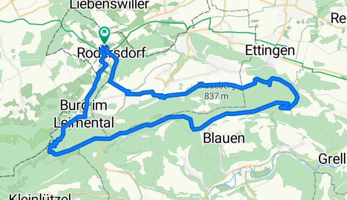
um den Blauen
A cycling route starting in Leymen, Grand Est, France.
Overview
About this route
R'dorf-Metzerlen-Hofstetten-Blattenpass-Chall-Burg-Biederthal-R'dorf
(cloned from route 2491318)
- -:--
- Duration
- 29.8 km
- Distance
- 761 m
- Ascent
- 761 m
- Descent
- ---
- Avg. speed
- ---
- Max. altitude

Continue with Bikemap
Use, edit, or download this cycling route
You would like to ride um den Blauen or customize it for your own trip? Here is what you can do with this Bikemap route:
Free features
- Save this route as favorite or in collections
- Copy & plan your own version of this route
- Sync your route with Garmin or Wahoo
Premium features
Free trial for 3 days, or one-time payment. More about Bikemap Premium.
- Navigate this route on iOS & Android
- Export a GPX / KML file of this route
- Create your custom printout (try it for free)
- Download this route for offline navigation
Discover more Premium features.
Get Bikemap PremiumFrom our community
Other popular routes starting in Leymen
 69km Bike R'dorf-G'berg-Pt_Kohlberg-Grande Roche-Habschelle
- Distance
- 69.3 km
- Ascent
- 1,702 m
- Descent
- 1,702 m
- Location
- Leymen, Grand Est, France
 27km R'dorf-Oberwil-Allschwil-Hagenthal
- Distance
- 27.4 km
- Ascent
- 285 m
- Descent
- 286 m
- Location
- Leymen, Grand Est, France
 ZZ FRANCE Elsass Wolschwiller-Wolschwiller
- Distance
- 89.3 km
- Ascent
- 470 m
- Descent
- 470 m
- Location
- Leymen, Grand Est, France
 85km Rennvelo - R'dorf-Gempen-Reigoldswil-Büsserach-Laufen-Aesch-Hofstetten-Metzerlen
- Distance
- 85.8 km
- Ascent
- 989 m
- Descent
- 989 m
- Location
- Leymen, Grand Est, France
 35km Elsass
- Distance
- 34.7 km
- Ascent
- 388 m
- Descent
- 386 m
- Location
- Leymen, Grand Est, France
 Gerade Fahrt in Hagenthal-le-Bas
- Distance
- 5.1 km
- Ascent
- 48 m
- Descent
- 100 m
- Location
- Leymen, Grand Est, France
 Rodersdorf - Pt Kohlberg - Lucelle - Rämel
- Distance
- 60.7 km
- Ascent
- 1,190 m
- Descent
- 1,190 m
- Location
- Leymen, Grand Est, France
 15km MTB Metzerlerchrütz&Downhill
- Distance
- 15.3 km
- Ascent
- 486 m
- Descent
- 486 m
- Location
- Leymen, Grand Est, France
Open it in the app