

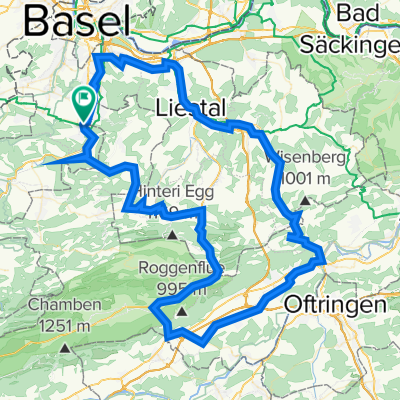
Aesch, Reigoldswil, Waldenburg, Balsthal, Oensingen, Olten, Läufelfingen, Sissach, Pratteln, Münchenstein, Aesch
A cycling route starting in Aesch, Basel-Landschaft, Switzerland.
Overview
About this route
Die Route stimmt strassenmässig nicht ganz überein. Jeweils Ausschilderung Radweg beachten. Zwischen Oensingen / Kestenholz den Inlineweg nehmen, das Stück Radweg ist nicht geteert.
- -:--
- Duration
- 114 km
- Distance
- 1,030 m
- Ascent
- 1,030 m
- Descent
- ---
- Avg. speed
- ---
- Max. altitude

Route quality
Waytypes & surfaces along the route
Waytypes
Busy road
58.2 km
(51 %)
Road
28.6 km
(25 %)
Surfaces
Paved
82.5 km
(72 %)
Unpaved
1 km
(<1 %)
Asphalt
80.5 km
(71 %)
Paved (undefined)
1.5 km
(1 %)
Continue with Bikemap
Use, edit, or download this cycling route
You would like to ride Aesch, Reigoldswil, Waldenburg, Balsthal, Oensingen, Olten, Läufelfingen, Sissach, Pratteln, Münchenstein, Aesch or customize it for your own trip? Here is what you can do with this Bikemap route:
Free features
- Save this route as favorite or in collections
- Copy & plan your own version of this route
- Split it into stages to create a multi-day tour
- Sync your route with Garmin or Wahoo
Premium features
Free trial for 3 days, or one-time payment. More about Bikemap Premium.
- Navigate this route on iOS & Android
- Export a GPX / KML file of this route
- Create your custom printout (try it for free)
- Download this route for offline navigation
Discover more Premium features.
Get Bikemap PremiumFrom our community
Other popular routes starting in Aesch
 Dornach-Aesch-Pfeffingen-Röschenz-Laufen-Zwingen-Grellingen-Duggingen-Dornach
- Distance
- 39.1 km
- Ascent
- 823 m
- Descent
- 825 m
- Location
- Aesch, Basel-Landschaft, Switzerland
 Angenstein - Passwang (MTB)
- Distance
- 56.6 km
- Ascent
- 1,501 m
- Descent
- 1,501 m
- Location
- Aesch, Basel-Landschaft, Switzerland
 Jura-Bärgfloh Rundi
- Distance
- 61.7 km
- Ascent
- 1,640 m
- Descent
- 1,642 m
- Location
- Aesch, Basel-Landschaft, Switzerland
 Aesch (BL) - Laufen - Baettwil - Ettingen
- Distance
- 37.1 km
- Ascent
- 574 m
- Descent
- 575 m
- Location
- Aesch, Basel-Landschaft, Switzerland
 Aesch - Erschwil - Nunningerberg - Gempen - Aesch
- Distance
- 57.5 km
- Ascent
- 1,627 m
- Descent
- 1,424 m
- Location
- Aesch, Basel-Landschaft, Switzerland
 Dornach > Gempen > Nord Trail > Dornach
- Distance
- 20.8 km
- Ascent
- 652 m
- Descent
- 652 m
- Location
- Aesch, Basel-Landschaft, Switzerland
 Aesch, Reigoldswil, Waldenburg, Balsthal, Oensingen, Olten, Läufelfingen, Sissach, Pratteln, Münchenstein, Aesch
- Distance
- 114 km
- Ascent
- 1,030 m
- Descent
- 1,030 m
- Location
- Aesch, Basel-Landschaft, Switzerland
 Aesch-enlang Blauen-Rodersdorf
- Distance
- 21.2 km
- Ascent
- 585 m
- Descent
- 547 m
- Location
- Aesch, Basel-Landschaft, Switzerland
Open it in the app