
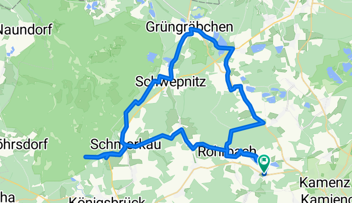
Rundtour südöstlich der Königsbrücker Heide
A cycling route starting in Neukirch, Saxony, Germany.
Overview
About this route
Kleine nette Runde mit Weitblick vom Haselbergturm in die Königsbrücker Heide.
09.03.2014- -:--
- Duration
- 43.8 km
- Distance
- 176 m
- Ascent
- 175 m
- Descent
- ---
- Avg. speed
- ---
- Avg. speed
Route quality
Waytypes & surfaces along the route
Waytypes
Quiet road
19.5 km
(45 %)
Track
11.8 km
(27 %)
Surfaces
Paved
10.7 km
(24 %)
Unpaved
14 km
(32 %)
Asphalt
10.3 km
(24 %)
Gravel
7.3 km
(17 %)
Route highlights
Points of interest along the route
Point of interest after 16.3 km
Pause in der Gaststätte "Zum alten Schlachthaus" (lecker Rotkraut)
Point of interest after 28.3 km
Haselbergturm mit schönem Rastplatz
Continue with Bikemap
Use, edit, or download this cycling route
You would like to ride Rundtour südöstlich der Königsbrücker Heide or customize it for your own trip? Here is what you can do with this Bikemap route:
Free features
- Save this route as favorite or in collections
- Copy & plan your own version of this route
- Sync your route with Garmin or Wahoo
Premium features
Free trial for 3 days, or one-time payment. More about Bikemap Premium.
- Navigate this route on iOS & Android
- Export a GPX / KML file of this route
- Create your custom printout (try it for free)
- Download this route for offline navigation
Discover more Premium features.
Get Bikemap PremiumFrom our community
Other popular routes starting in Neukirch
 Rundtour südöstlich der Königsbrücker Heide
- Distance
- 43.8 km
- Ascent
- 176 m
- Descent
- 175 m
- Location
- Neukirch, Saxony, Germany
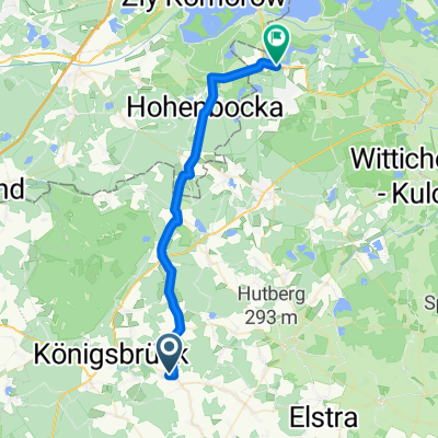
 Königsbrücker Straße 219, Schönteichen nach Greifswalder Straße 32, Senftenberg
- Distance
- 442.8 km
- Ascent
- 201 m
- Descent
- 287 m
- Location
- Neukirch, Saxony, Germany
 Otterbach Schmorkau
- Distance
- 12.4 km
- Ascent
- 13 m
- Descent
- 55 m
- Location
- Neukirch, Saxony, Germany
 lauta kurz
- Distance
- 30.8 km
- Ascent
- 72 m
- Descent
- 153 m
- Location
- Neukirch, Saxony, Germany
 Lausitzrunde von Schwosdorf zum Hochstein und zurück
- Distance
- 30.7 km
- Ascent
- 510 m
- Descent
- 507 m
- Location
- Neukirch, Saxony, Germany
 Teichweg
- Distance
- 44.5 km
- Ascent
- 165 m
- Descent
- 168 m
- Location
- Neukirch, Saxony, Germany
 Neukirch - Grünewald - Kamenz - Neukirch
- Distance
- 75.3 km
- Ascent
- 208 m
- Descent
- 208 m
- Location
- Neukirch, Saxony, Germany
 Kleine Runde in der Heimat
- Distance
- 53.7 km
- Ascent
- 258 m
- Descent
- 256 m
- Location
- Neukirch, Saxony, Germany
Open it in the app