

Lac de Thoune par les hauts
A cycling route starting in Kandersteg, Canton of Bern, Switzerland.
Overview
About this route
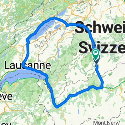
Starting from Kandersteg, descend through the Kandertal via the beautiful cycling route. In Thun, instead of following the lakeside road, climb up to Heiligenschwendi, descend to Sigriswil, climb up to Beatenberg, and descend to Unterseen (Interlaken). The return is made along the southern shore, ascending towards Aeschi-bei-Spiez, descending to Mülenen, and then climbing back up the Kandertal towards Frutigen and Kandersteg.
- -:--
- Duration
- 122.7 km
- Distance
- 1,757 m
- Ascent
- 1,757 m
- Descent
- ---
- Avg. speed
- ---
- Max. altitude

Route quality
Waytypes & surfaces along the route
Waytypes
Road
46.6 km
(38 %)
Quiet road
46.6 km
(38 %)
Surfaces
Paved
68.7 km
(56 %)
Asphalt
68.7 km
(56 %)
Undefined
54 km
(44 %)
Continue with Bikemap
Use, edit, or download this cycling route
You would like to ride Lac de Thoune par les hauts or customize it for your own trip? Here is what you can do with this Bikemap route:
Free features
- Save this route as favorite or in collections
- Copy & plan your own version of this route
- Split it into stages to create a multi-day tour
- Sync your route with Garmin or Wahoo
Premium features
Free trial for 3 days, or one-time payment. More about Bikemap Premium.
- Navigate this route on iOS & Android
- Export a GPX / KML file of this route
- Create your custom printout (try it for free)
- Download this route for offline navigation
Discover more Premium features.
Get Bikemap PremiumFrom our community
Other popular routes starting in Kandersteg
 2012.0730:Suisse-B.Alps:Kandersteg-Heimritz-Frutigen-Wimmis-U.
- Distance
- 60.3 km
- Ascent
- 1,648 m
- Descent
- 2,293 m
- Location
- Kandersteg, Canton of Bern, Switzerland
 Oeschinentrip
- Distance
- 9.5 km
- Ascent
- 535 m
- Descent
- 536 m
- Location
- Kandersteg, Canton of Bern, Switzerland
 Winderspaziergang Griesalp Kiental
- Distance
- 8.7 km
- Ascent
- 314 m
- Descent
- 608 m
- Location
- Kandersteg, Canton of Bern, Switzerland
 Kandersteg - Thun
- Distance
- 41.9 km
- Ascent
- 563 m
- Descent
- 1,171 m
- Location
- Kandersteg, Canton of Bern, Switzerland
 Kandersteg - Sion
- Distance
- 126.9 km
- Ascent
- ---
- Descent
- ---
- Location
- Kandersteg, Canton of Bern, Switzerland
 Trans Oberwallis Day 2
- Distance
- 32.3 km
- Ascent
- 2,507 m
- Descent
- 1,892 m
- Location
- Kandersteg, Canton of Bern, Switzerland
 Birdhead
- Distance
- 419.4 km
- Ascent
- 1,442 m
- Descent
- 1,392 m
- Location
- Kandersteg, Canton of Bern, Switzerland
 Cavallotrip
- Distance
- 336.1 km
- Ascent
- 2,175 m
- Descent
- 2,320 m
- Location
- Kandersteg, Canton of Bern, Switzerland
Open it in the app