

Puntalarga - Finca San Pedro - Puntalarga
A cycling route starting in Tibasosa, Departamento de Boyacá, Colombia.
Overview
About this route
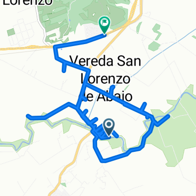
Puntalarga - Finca San Pedro - Puntalarga
- -:--
- Duration
- 38.1 km
- Distance
- 209 m
- Ascent
- 212 m
- Descent
- ---
- Avg. speed
- ---
- Max. altitude

Continue with Bikemap
Use, edit, or download this cycling route
You would like to ride Puntalarga - Finca San Pedro - Puntalarga or customize it for your own trip? Here is what you can do with this Bikemap route:
Free features
- Save this route as favorite or in collections
- Copy & plan your own version of this route
- Sync your route with Garmin or Wahoo
Premium features
Free trial for 3 days, or one-time payment. More about Bikemap Premium.
- Navigate this route on iOS & Android
- Export a GPX / KML file of this route
- Create your custom printout (try it for free)
- Download this route for offline navigation
Discover more Premium features.
Get Bikemap PremiumFrom our community
Other popular routes starting in Tibasosa
 Sector Puente La Balsa
- Distance
- 18.9 km
- Ascent
- 142 m
- Descent
- 156 m
- Location
- Tibasosa, Departamento de Boyacá, Colombia
 tibasosa guatica
- Distance
- 16 km
- Ascent
- 861 m
- Descent
- 600 m
- Location
- Tibasosa, Departamento de Boyacá, Colombia
 Rodear Laguna de Tota
- Distance
- 106 km
- Ascent
- 1,337 m
- Descent
- 1,330 m
- Location
- Tibasosa, Departamento de Boyacá, Colombia
 De Duitama-Sogamoso a Duitama-Sogamoso
- Distance
- 53.2 km
- Ascent
- 1,234 m
- Descent
- 1,234 m
- Location
- Tibasosa, Departamento de Boyacá, Colombia
 De Pantano De Vargas-Duitama a Calle 16 15-5, Duitama
- Distance
- 16 km
- Ascent
- 135 m
- Descent
- 115 m
- Location
- Tibasosa, Departamento de Boyacá, Colombia
 De Calle 3 11-35, Tibasosa a Calle 3 11-57, Tibasosa
- Distance
- 28.1 km
- Ascent
- 429 m
- Descent
- 171 m
- Location
- Tibasosa, Departamento de Boyacá, Colombia
 Puntalarta - Sogamoso - Puntalarga (28km)
- Distance
- 28.1 km
- Ascent
- 200 m
- Descent
- 200 m
- Location
- Tibasosa, Departamento de Boyacá, Colombia
 De Calle 3 11-57, Tibasosa a Calle 3 11-57, Tibasosa
- Distance
- 40.7 km
- Ascent
- 716 m
- Descent
- 708 m
- Location
- Tibasosa, Departamento de Boyacá, Colombia
Open it in the app