
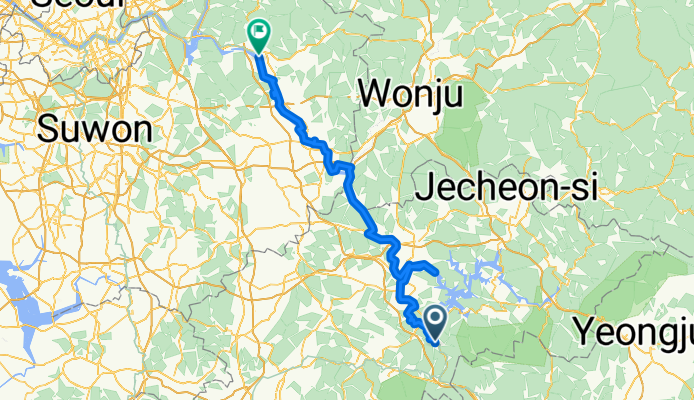
韓国縦走サイクリング5日目(水安堡→楊平)
A cycling route starting in Mungyeong, Gyeongsangbuk-do, South Korea.
Overview
About this route
途中、忠州ダムに寄ったのだか、これが意外に足を使った。このころから少し疲労が蓄積し始める。京畿道に入ったら道が良くなった。
この日から漢江に入る。河原で韓国陸軍が訓練してました。- -:--
- Duration
- 148.9 km
- Distance
- 300 m
- Ascent
- 459 m
- Descent
- ---
- Avg. speed
- ---
- Max. altitude

Route quality
Waytypes & surfaces along the route
Waytypes
Cycleway
87.9 km
(59 %)
Road
43.2 km
(29 %)
Surfaces
Paved
138.5 km
(93 %)
Asphalt
122.1 km
(82 %)
Concrete
14.9 km
(10 %)
Continue with Bikemap
Use, edit, or download this cycling route
You would like to ride 韓国縦走サイクリング5日目(水安堡→楊平) or customize it for your own trip? Here is what you can do with this Bikemap route:
Free features
- Save this route as favorite or in collections
- Copy & plan your own version of this route
- Split it into stages to create a multi-day tour
- Sync your route with Garmin or Wahoo
Premium features
Free trial for 3 days, or one-time payment. More about Bikemap Premium.
- Navigate this route on iOS & Android
- Export a GPX / KML file of this route
- Create your custom printout (try it for free)
- Download this route for offline navigation
Discover more Premium features.
Get Bikemap PremiumFrom our community
Other popular routes starting in Mungyeong
 hotel
hotel- Distance
- 26.3 km
- Ascent
- 227 m
- Descent
- 307 m
- Location
- Mungyeong, Gyeongsangbuk-do, South Korea
 Incheon to Busan Day 3
- Distance
- 121.6 km
- Ascent
- 510 m
- Descent
- 669 m
- Location
- Mungyeong, Gyeongsangbuk-do, South Korea
 괴산메디오폰도
- Distance
- 106.6 km
- Ascent
- 2,326 m
- Descent
- 2,035 m
- Location
- Mungyeong, Gyeongsangbuk-do, South Korea
 韓国縦走サイクリング5日目(水安堡→楊平)
- Distance
- 148.9 km
- Ascent
- 300 m
- Descent
- 459 m
- Location
- Mungyeong, Gyeongsangbuk-do, South Korea
 수안보면 446−7, 충주시 to 수안보면 279−9, 충주시
- Distance
- 98.4 km
- Ascent
- 1,164 m
- Descent
- 1,174 m
- Location
- Mungyeong, Gyeongsangbuk-do, South Korea
 Day#4
Day#4- Distance
- 91.3 km
- Ascent
- 1,027 m
- Descent
- 1,175 m
- Location
- Mungyeong, Gyeongsangbuk-do, South Korea
 535-4, Haengchon-ri, to Jungwon-daero,
- Distance
- 0.3 km
- Ascent
- 11 m
- Descent
- 0 m
- Location
- Mungyeong, Gyeongsangbuk-do, South Korea
 이화령로, 문경시에서 불정동, 문경시까지
- Distance
- 22.1 km
- Ascent
- 64 m
- Descent
- 492 m
- Location
- Mungyeong, Gyeongsangbuk-do, South Korea
Open it in the app