

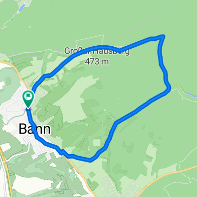
Bann-Wallhalbtal-Steinalbtal-Bann
A cycling route starting in Bann, Rhineland-Palatinate, Germany.
Overview
About this route
- -:--
- Duration
- 50.8 km
- Distance
- 707 m
- Ascent
- 755 m
- Descent
- ---
- Avg. speed
- 422 m
- Max. altitude
Route quality
Waytypes & surfaces along the route
Waytypes
Busy road
42.2 km
(83 %)
Track
3.1 km
(6 %)
Surfaces
Paved
28.9 km
(57 %)
Unpaved
1.1 km
(2 %)
Asphalt
28.3 km
(56 %)
Gravel
0.8 km
(1 %)
Continue with Bikemap
Use, edit, or download this cycling route
You would like to ride Bann-Wallhalbtal-Steinalbtal-Bann or customize it for your own trip? Here is what you can do with this Bikemap route:
Free features
- Save this route as favorite or in collections
- Copy & plan your own version of this route
- Sync your route with Garmin or Wahoo
Premium features
Free trial for 3 days, or one-time payment. More about Bikemap Premium.
- Navigate this route on iOS & Android
- Export a GPX / KML file of this route
- Create your custom printout (try it for free)
- Download this route for offline navigation
Discover more Premium features.
Get Bikemap PremiumFrom our community
Other popular routes starting in Bann
 Bann - Rund um den Hausberg
- Distance
- 8.4 km
- Ascent
- 119 m
- Descent
- 104 m
- Location
- Bann, Rhineland-Palatinate, Germany
 Bann-Steinalbtal-Hackenberg-Wallhalbtal-Mittelbrunn-Bann
- Distance
- 49 km
- Ascent
- 648 m
- Descent
- 651 m
- Location
- Bann, Rhineland-Palatinate, Germany
 A62, Bann to K60, Bann
- Distance
- 13.9 km
- Ascent
- 99 m
- Descent
- 89 m
- Location
- Bann, Rhineland-Palatinate, Germany
 Queidersbach-Linden-Hornbach-Heltersberg-Waldfischbach-Hermersberg-Weselberg-Bann-Queidersbach 45km
- Distance
- 44.9 km
- Ascent
- 417 m
- Descent
- 422 m
- Location
- Bann, Rhineland-Palatinate, Germany
 Bann-Migné-Auxances
- Distance
- 793.5 km
- Ascent
- 2,690 m
- Descent
- 2,958 m
- Location
- Bann, Rhineland-Palatinate, Germany
 Bann-Homburg-Zweibrücken-Bann
- Distance
- 83.5 km
- Ascent
- 641 m
- Descent
- 706 m
- Location
- Bann, Rhineland-Palatinate, Germany
 35. Großer Preis der Sickinger Höhe
- Distance
- 14.4 km
- Ascent
- 167 m
- Descent
- 167 m
- Location
- Bann, Rhineland-Palatinate, Germany
 Walkmühltal - Forsthaus - Silbersee
- Distance
- 4.4 km
- Ascent
- 87 m
- Descent
- 41 m
- Location
- Bann, Rhineland-Palatinate, Germany
Open it in the app