
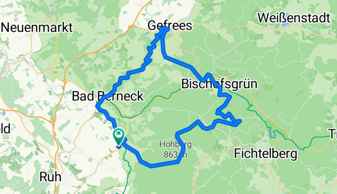
Hirtenstein-Ochsenkopf_Gefrees zum Kaffeetrinken
A cycling route starting in Goldkronach, Bavaria, Germany.
Overview
About this route
47 km with 1100 m of elevation
Great tour, lots of forest and beautiful climbs with descents. Few single trails, but 1 very challenging section..- -:--
- Duration
- 47.8 km
- Distance
- 920 m
- Ascent
- 924 m
- Descent
- ---
- Avg. speed
- ---
- Max. altitude

Route quality
Waytypes & surfaces along the route
Waytypes
Track
28.7 km
(60 %)
Quiet road
13.4 km
(28 %)
Surfaces
Paved
9.6 km
(20 %)
Unpaved
28.7 km
(60 %)
Gravel
23.9 km
(50 %)
Asphalt
9.1 km
(19 %)
Continue with Bikemap
Use, edit, or download this cycling route
You would like to ride Hirtenstein-Ochsenkopf_Gefrees zum Kaffeetrinken or customize it for your own trip? Here is what you can do with this Bikemap route:
Free features
- Save this route as favorite or in collections
- Copy & plan your own version of this route
- Sync your route with Garmin or Wahoo
Premium features
Free trial for 3 days, or one-time payment. More about Bikemap Premium.
- Navigate this route on iOS & Android
- Export a GPX / KML file of this route
- Create your custom printout (try it for free)
- Download this route for offline navigation
Discover more Premium features.
Get Bikemap PremiumFrom our community
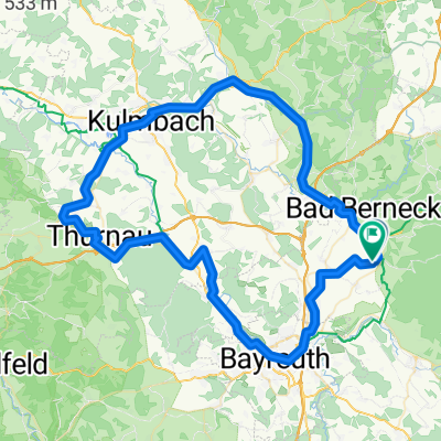
Other popular routes starting in Goldkronach
 Oberpfälzer Runde
- Distance
- 152.7 km
- Ascent
- 1,260 m
- Descent
- 1,276 m
- Location
- Goldkronach, Bavaria, Germany
 Goldkronach zum Ochsenkopf
- Distance
- 54.6 km
- Ascent
- 1,398 m
- Descent
- 1,369 m
- Location
- Goldkronach, Bavaria, Germany
 Sickenreuth->Hirschhorn->Föllmar->Goldkronach
- Distance
- 16.9 km
- Ascent
- 478 m
- Descent
- 479 m
- Location
- Goldkronach, Bavaria, Germany
 Ostertour
- Distance
- 61.6 km
- Ascent
- 486 m
- Descent
- 486 m
- Location
- Goldkronach, Bavaria, Germany
 Plassenburg - Markgrafgenweg Goldkronach-Bayreuth-Kulmbach
- Distance
- 66.2 km
- Ascent
- 849 m
- Descent
- 846 m
- Location
- Goldkronach, Bavaria, Germany
 Rundum
- Distance
- 12.7 km
- Ascent
- 303 m
- Descent
- 478 m
- Location
- Goldkronach, Bavaria, Germany
 Kulmbach bt
- Distance
- 82.8 km
- Ascent
- 753 m
- Descent
- 753 m
- Location
- Goldkronach, Bavaria, Germany
 Moosbachsteig (Gustavsruhe) - Jägersteig - Trailrunde
- Distance
- 31.3 km
- Ascent
- 807 m
- Descent
- 807 m
- Location
- Goldkronach, Bavaria, Germany
Open it in the app