
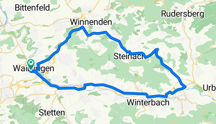
WN: Schorndorf - Winnenden
A cycling route starting in Waiblingen, Baden-Wurttemberg, Germany.
Overview
About this route
- -:--
- Duration
- 42.2 km
- Distance
- 395 m
- Ascent
- 361 m
- Descent
- ---
- Avg. speed
- 415 m
- Max. altitude

Route quality
Waytypes & surfaces along the route
Waytypes
Road
23.2 km
(55 %)
Track
3.4 km
(8 %)
Surfaces
Paved
41.3 km
(98 %)
Asphalt
40.1 km
(95 %)
Paved (undefined)
1.3 km
(3 %)
Undefined
0.8 km
(2 %)
Continue with Bikemap
Use, edit, or download this cycling route
You would like to ride WN: Schorndorf - Winnenden or customize it for your own trip? Here is what you can do with this Bikemap route:
Free features
- Save this route as favorite or in collections
- Copy & plan your own version of this route
- Sync your route with Garmin or Wahoo
Premium features
Free trial for 3 days, or one-time payment. More about Bikemap Premium.
- Navigate this route on iOS & Android
- Export a GPX / KML file of this route
- Create your custom printout (try it for free)
- Download this route for offline navigation
Discover more Premium features.
Get Bikemap PremiumFrom our community
Other popular routes starting in Waiblingen
 Rems - Neckar - Fellbach - Waiblingen
- Distance
- 48.5 km
- Ascent
- 398 m
- Descent
- 391 m
- Location
- Waiblingen, Baden-Wurttemberg, Germany
 Waiblingen-Remseck-Fellbach-WN
- Distance
- 37 km
- Ascent
- 152 m
- Descent
- 188 m
- Location
- Waiblingen, Baden-Wurttemberg, Germany
 Tour de Schnait
- Distance
- 36.3 km
- Ascent
- 379 m
- Descent
- 378 m
- Location
- Waiblingen, Baden-Wurttemberg, Germany
 Ameisenbühl 1, Waiblingen nach Ameisenbühl 8, Waiblingen
- Distance
- 19 km
- Ascent
- 7 m
- Descent
- 16 m
- Location
- Waiblingen, Baden-Wurttemberg, Germany
 Rems und Neckar
- Distance
- 52.1 km
- Ascent
- 181 m
- Descent
- 196 m
- Location
- Waiblingen, Baden-Wurttemberg, Germany
 WAIBLINGEN-NECKLINSBERG-SCHORNDORF-WAIBLINGEN
- Distance
- 47.8 km
- Ascent
- 314 m
- Descent
- 312 m
- Location
- Waiblingen, Baden-Wurttemberg, Germany
 Waiblingen über Schmiden am Besinnungsweg entlang bis zum Mount Oeffingen und zum Max-Eyth -See
- Distance
- 21.6 km
- Ascent
- 72 m
- Descent
- 185 m
- Location
- Waiblingen, Baden-Wurttemberg, Germany
 Abendrunde
- Distance
- 29.6 km
- Ascent
- 412 m
- Descent
- 415 m
- Location
- Waiblingen, Baden-Wurttemberg, Germany
Open it in the app