

Cassis - Barjols
A cycling route starting in Cassis, Provence-Alpes-Côte d'Azur Region, France.
Overview
About this route
2nd stage of my trip to France '08:
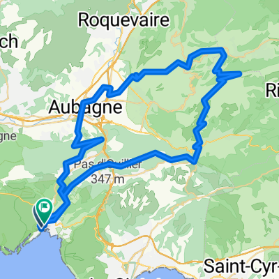
Cassis
Mont de la Saoupe
Grde de Tête
La Ciotat
Ceyreste
Mauregard
Le Grd Caunet
Towards Pinval / Gemenos
Gemenos
Col d'Espigoulier
Plan-D'Aups
Mazaugues
Les Censiés
Bras
Saint Estève
Brue Auriac
Barjols
- -:--
- Duration
- 116.9 km
- Distance
- 1,705 m
- Ascent
- 1,542 m
- Descent
- ---
- Avg. speed
- ---
- Max. altitude

Continue with Bikemap
Use, edit, or download this cycling route
You would like to ride Cassis - Barjols or customize it for your own trip? Here is what you can do with this Bikemap route:
Free features
- Save this route as favorite or in collections
- Copy & plan your own version of this route
- Split it into stages to create a multi-day tour
- Sync your route with Garmin or Wahoo
Premium features
Free trial for 3 days, or one-time payment. More about Bikemap Premium.
- Navigate this route on iOS & Android
- Export a GPX / KML file of this route
- Create your custom printout (try it for free)
- Download this route for offline navigation
Discover more Premium features.
Get Bikemap PremiumFrom our community
Other popular routes starting in Cassis
 calanque d’en vau
- Distance
- 16 km
- Ascent
- 332 m
- Descent
- 326 m
- Location
- Cassis, Provence-Alpes-Côte d'Azur Region, France
 2016J22JourA : Cassis Gare
- Distance
- 2 km
- Ascent
- 32 m
- Descent
- 0 m
- Location
- Cassis, Provence-Alpes-Côte d'Azur Region, France
 Cassis - Hapimag 51 km
- Distance
- 51.8 km
- Ascent
- 1,000 m
- Descent
- 1,001 m
- Location
- Cassis, Provence-Alpes-Côte d'Azur Region, France
 La Ciotat-callanques_cassis
- Distance
- 30.6 km
- Ascent
- 879 m
- Descent
- 880 m
- Location
- Cassis, Provence-Alpes-Côte d'Azur Region, France
 callanques_cassis
- Distance
- 30.6 km
- Ascent
- 916 m
- Descent
- 915 m
- Location
- Cassis, Provence-Alpes-Côte d'Azur Region, France
 Cassis - Pic de Bertagne - Cassis
- Distance
- 64.6 km
- Ascent
- 2,181 m
- Descent
- 2,171 m
- Location
- Cassis, Provence-Alpes-Côte d'Azur Region, France
 ride from Cassis to Marseille
- Distance
- 21.4 km
- Ascent
- 249 m
- Descent
- 395 m
- Location
- Cassis, Provence-Alpes-Côte d'Azur Region, France
 Barcelona 11
- Distance
- 66 km
- Ascent
- 750 m
- Descent
- 737 m
- Location
- Cassis, Provence-Alpes-Côte d'Azur Region, France
Open it in the app