

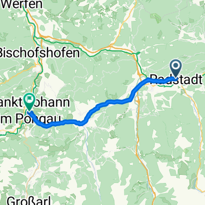
Enns - Duna - 2009 - 2.deň
A cycling route starting in Radstadt, Salzburg, Austria.
Overview
About this route
Stage: Radstadt - Hall
The entire route is along a marked cycle tourist path.
Accommodation at Gasthof Wölger - Hall 16 E-mail: gasthof_woelger@a1.net
Information in Hungarian: pipper@inmail.sk
- -:--
- Duration
- 108.3 km
- Distance
- 733 m
- Ascent
- 923 m
- Descent
- ---
- Avg. speed
- 855 m
- Max. altitude

Route quality
Waytypes & surfaces along the route
Waytypes
Quiet road
30.3 km
(28 %)
Track
21.7 km
(20 %)
Surfaces
Paved
49.8 km
(46 %)
Unpaved
16.2 km
(15 %)
Asphalt
48.7 km
(45 %)
Gravel
11.9 km
(11 %)
Route highlights
Points of interest along the route

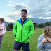
Photo after 1.9 km

Photo after 17 km

Photo after 39.8 km

Photo after 45.9 km

Photo after 54.8 km

Photo after 71.1 km

Photo after 74.2 km

Photo after 80.8 km

Photo after 96.5 km

Photo after 101.3 km
Continue with Bikemap
Use, edit, or download this cycling route
You would like to ride Enns - Duna - 2009 - 2.deň or customize it for your own trip? Here is what you can do with this Bikemap route:
Free features
- Save this route as favorite or in collections
- Copy & plan your own version of this route
- Split it into stages to create a multi-day tour
- Sync your route with Garmin or Wahoo
Premium features
Free trial for 3 days, or one-time payment. More about Bikemap Premium.
- Navigate this route on iOS & Android
- Export a GPX / KML file of this route
- Create your custom printout (try it for free)
- Download this route for offline navigation
Discover more Premium features.
Get Bikemap PremiumFrom our community
Other popular routes starting in Radstadt
 Schladming
- Distance
- 51.9 km
- Ascent
- 299 m
- Descent
- 318 m
- Location
- Radstadt, Salzburg, Austria
 Enns - Duna - 2009 - 2.deň
- Distance
- 108.3 km
- Ascent
- 733 m
- Descent
- 923 m
- Location
- Radstadt, Salzburg, Austria
 Ö_Salzburg_Radstadt-KönigslehenLift-Labeneck_LR-19.3km-740hm
- Distance
- 19.3 km
- Ascent
- 758 m
- Descent
- 756 m
- Location
- Radstadt, Salzburg, Austria
 Höggenstraße, Radstadt to Roßbrandstraße, Radstadt
- Distance
- 29 km
- Ascent
- 1,619 m
- Descent
- 759 m
- Location
- Radstadt, Salzburg, Austria
 Radstat_Enns_Linz
- Distance
- 237.9 km
- Ascent
- 244 m
- Descent
- 830 m
- Location
- Radstadt, Salzburg, Austria
 Girolibero: Ciclabile dell'Enns
- Distance
- 222.2 km
- Ascent
- 422 m
- Descent
- 976 m
- Location
- Radstadt, Salzburg, Austria
 Radstadt-Bürgerberg-Reitlehenrunde
- Distance
- 18.8 km
- Ascent
- 626 m
- Descent
- 627 m
- Location
- Radstadt, Salzburg, Austria
 Radstadt-SanktJohannimPongau
- Distance
- 24.9 km
- Ascent
- 227 m
- Descent
- 467 m
- Location
- Radstadt, Salzburg, Austria
Open it in the app