
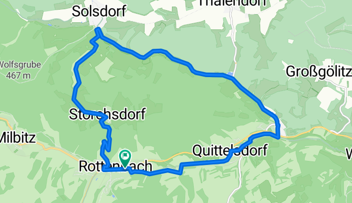
von Rottenbach ü. Storchsdorf, Solsdorf, Leutnitz zurück
A cycling route starting in Rottenbach, Free State of Thuringia, Germany.
Overview
About this route
nach dem "Erklimmen" der Storchsdorfer Höhe ist man gut erwärmt, Richtung Solsdorf dann herrlicher Blick auf die Gölitzwände und den Greifenstein, bis Leutnitz auf sehr ruhigen Nebenstraßen und auf dem Rinnetalradweg zurück
- -:--
- Duration
- 12.5 km
- Distance
- 211 m
- Ascent
- 212 m
- Descent
- ---
- Avg. speed
- 441 m
- Max. altitude
Route quality
Waytypes & surfaces along the route
Waytypes
Road
4.5 km
(36 %)
Path
2.9 km
(23 %)
Surfaces
Paved
9.2 km
(73 %)
Unpaved
2.9 km
(23 %)
Asphalt
8.5 km
(68 %)
Ground
1.8 km
(15 %)
Continue with Bikemap
Use, edit, or download this cycling route
You would like to ride von Rottenbach ü. Storchsdorf, Solsdorf, Leutnitz zurück or customize it for your own trip? Here is what you can do with this Bikemap route:
Free features
- Save this route as favorite or in collections
- Copy & plan your own version of this route
- Sync your route with Garmin or Wahoo
Premium features
Free trial for 3 days, or one-time payment. More about Bikemap Premium.
- Navigate this route on iOS & Android
- Export a GPX / KML file of this route
- Create your custom printout (try it for free)
- Download this route for offline navigation
Discover more Premium features.
Get Bikemap PremiumFrom our community
Other popular routes starting in Rottenbach
 Rottenbach - kleinliebringen und zurück
- Distance
- 29.6 km
- Ascent
- 365 m
- Descent
- 362 m
- Location
- Rottenbach, Free State of Thuringia, Germany
 Rottenbach-Milbitz-Horba-Buchberg u. zurück
- Distance
- 8.5 km
- Ascent
- 201 m
- Descent
- 170 m
- Location
- Rottenbach, Free State of Thuringia, Germany
 Gemeinderundfahrt 2012
- Distance
- 25.9 km
- Ascent
- 473 m
- Descent
- 408 m
- Location
- Rottenbach, Free State of Thuringia, Germany
 Rottenbach-Köditz-Aschau-Allendorf und zurück
- Distance
- 11.6 km
- Ascent
- 199 m
- Descent
- 199 m
- Location
- Rottenbach, Free State of Thuringia, Germany
 Leutnitz-Katschen Weichau
- Distance
- 102.8 km
- Ascent
- 350 m
- Descent
- 486 m
- Location
- Rottenbach, Free State of Thuringia, Germany
 Rottenbach - Allendorf - Bechstedt u. zurück
- Distance
- 9.7 km
- Ascent
- 131 m
- Descent
- 66 m
- Location
- Rottenbach, Free State of Thuringia, Germany
 Rottenbach-Leutnitz-Thälendorf-Solsdorf-Storchsdorf-R.
- Distance
- 15 km
- Ascent
- 228 m
- Descent
- 144 m
- Location
- Rottenbach, Free State of Thuringia, Germany
 Rundfahrt Gemeinde Rottenbach 2011
- Distance
- 27.1 km
- Ascent
- 469 m
- Descent
- 423 m
- Location
- Rottenbach, Free State of Thuringia, Germany
Open it in the app