

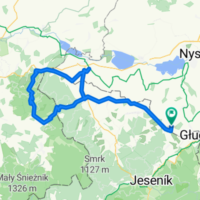
Obóz w Głuchołazach: Wycieczka na Pradziada
A cycling route starting in Głuchołazy, Opole Voivodeship, Poland.
Overview
About this route
Another day of battling the mountains surrounding Głuchołazy, our base camp. Due to yesterday's intensive rain and thunderstorm, we decided to take an asphalt trip to the highest peak of the Jeseníky - Praded (1492 m above sea level) against our MTB philosophy. Starting after 10 a.m., with the sun intensely blazing. Only the loud whoosh of off-road tires on asphalt. In the Czech Republic, riding was very good. Beautiful asphalt roads, zero potholes and always uphill. After reaching Rejviz, we decided to continue on to Vrbno pod Pradadem using the red trail, as the map indicated it was either asphalt or gravel. We were not surprised, only a short section soaked and dirtied us. The rest was asphalt even in the middle of the forest and quite a few people were met on trekking bikes. In Vrbno, we visited a Czech bike shop to see what they had. Ah yes, mainly Author and Kellys... their national brands ;-) and Nutrend supplements. Then more asphalt to Karlowa Studanka. Here a drink stop like in Rymanów, I didn’t take any and that was a mistake. And now the lack of detailed map study on my part resulted in several kilometers of senseless grinding uphill. Instead of turning left, we went right towards Vidly. Here non-stop uphill for several kilometers. then down through winding serpentines. Only on the lower map did it turn out we had gone the wrong way... no one wanted to ride off-road anymore, remembering the burden of carrying bikes the day before, we wanted to reach our destination on bikes... so back. And now this beautiful descent turned into a terrible climb. I had enough, I was left alone with the gearbox, the steepness and liters of sweat pouring down the frame and handlebars. Then at the summit, we tried to take a gravel road. And once again cursed myself for not uploading the TOPO map of Czechia to the Garmin, that we didn’t buy a Czech map of Jeseníky... But after getting to a certain point of gravel, we saw the road up through rubble and windfalls, so we turned back, descended to Karlowa Studanka and now certain of our goal, after previously refilling our water at a mountain stream, we set out for Pradziad. After reaching the parking lot at the foot of the mountain, it turned out to be about an 8-kilometer climb. I had enough, but the awareness that I was painfully climbing 600 meters at a speed of 8-9 km/h to reach the highest peak I had previously conquered on a bike (Praded 1492 m above sea level) energized me. Of course, Paweł sped far ahead. I saw Wojtek for a long time until my chain fell off and I had to stop to repair the bike. A bit with the crank, a bit standing, and I managed to get there. First to the intermediate station, where we could already see the RTV repeater on Pradziad, and then the final part standing like I was finishing some Tour. Only I was quite far behind Paweł. It was cold at the top, but the beautiful landscape surrounding us was worth it all. Good thing I brought a rain jacket because the harsh climatic conditions and low temperature caused a sudden cooling effect. The multi-kilometer descent that awaited us was incredible. We decided to descend through the terrain, it would be a shame to ride so much on asphalt. After descending from the peak and hitting the red trail, we encountered many surprises. As it later turned out, we had chosen an ultra-hardcore trail not very suitable for bikes. A lot of wooden walkways, climbing walls with the bike on the back and in SPD shoes were not pleasant, plus very difficult technical descents on sharp and well-secured stones. However, we managed (although Wojtuś had a small OTB, but it was harmless), the final descent on gravel and that speed resulted in beautiful outcomes. And so, in a short time, we managed to find ourselves from almost 1500 m to 900 m. Then long asphalt descents to Bělá pod Pradadem. From there on national road 44 through Mikulovice to Głuchołazy. On the way, to regain strength, we stopped at an Agip gas station and after drinking a Coca-Cola to alkalize the muscles, we continued on (how nice it is to pay with a VISA card all over the world). At one point, the road was closed, but that was just for cars, we managed without problems with the bike. The last uphill at the Polish-Czech border was very hard on tired muscles, but the subsequent descent into the town rewarded that suffering. After over 7 hours we returned safe and sound to the center. It was truly a tough expedition.Trip TipsDon’t go to Vidly. Plan your trip carefully. Don’t descend the red trail from Pradziad...
- -:--
- Duration
- 113 km
- Distance
- 2,309 m
- Ascent
- 2,025 m
- Descent
- ---
- Avg. speed
- 1,487 m
- Max. altitude
Route quality
Waytypes & surfaces along the route
Waytypes
Track
20.3 km
(18 %)
Road
11.3 km
(10 %)
Surfaces
Paved
67.8 km
(60 %)
Unpaved
4.5 km
(4 %)
Asphalt
62.2 km
(55 %)
Paved (undefined)
5.7 km
(5 %)
Continue with Bikemap
Use, edit, or download this cycling route
You would like to ride Obóz w Głuchołazach: Wycieczka na Pradziada or customize it for your own trip? Here is what you can do with this Bikemap route:
Free features
- Save this route as favorite or in collections
- Copy & plan your own version of this route
- Split it into stages to create a multi-day tour
- Sync your route with Garmin or Wahoo
Premium features
Free trial for 3 days, or one-time payment. More about Bikemap Premium.
- Navigate this route on iOS & Android
- Export a GPX / KML file of this route
- Create your custom printout (try it for free)
- Download this route for offline navigation
Discover more Premium features.
Get Bikemap PremiumFrom our community
Other popular routes starting in Głuchołazy
 Obóz w Głuchołazach: Wycieczka na Pradziada
- Distance
- 113 km
- Ascent
- 2,309 m
- Descent
- 2,025 m
- Location
- Głuchołazy, Opole Voivodeship, Poland
 dookoła Biskupiej Kopy - krotka
- Distance
- 27 km
- Ascent
- 458 m
- Descent
- 457 m
- Location
- Głuchołazy, Opole Voivodeship, Poland
 2007-05-26 Glucholazy Kopa Biskupia Głuchołazy
- Distance
- 36.2 km
- Ascent
- 784 m
- Descent
- 786 m
- Location
- Głuchołazy, Opole Voivodeship, Poland
 Pradziad ***
- Distance
- 111.5 km
- Ascent
- 1,831 m
- Descent
- 1,830 m
- Location
- Głuchołazy, Opole Voivodeship, Poland
 Sławniowice - Wrocław (Grodków, Oława)
- Distance
- 100.1 km
- Ascent
- 65 m
- Descent
- 261 m
- Location
- Głuchołazy, Opole Voivodeship, Poland
 Sławniowice - Sławniowice (przez Jesenik, Vidly, Karlovą Studankę, Vrbno, Zlate Hory, Mikulovice)
- Distance
- 85.6 km
- Ascent
- 1,236 m
- Descent
- 1,241 m
- Location
- Głuchołazy, Opole Voivodeship, Poland
 Trasa rodzinna - Gold Hill MTB Maraton Głuchołazy 2016
- Distance
- 13.2 km
- Ascent
- 417 m
- Descent
- 410 m
- Location
- Głuchołazy, Opole Voivodeship, Poland
 Sławniowice - Sławniowice (przez Javornik, Lądek Zdrój, Złoty Stok)
- Distance
- 99.9 km
- Ascent
- 930 m
- Descent
- 930 m
- Location
- Głuchołazy, Opole Voivodeship, Poland
Open it in the app