

Berliner Mauerweg Nordroute
A cycling route starting in Gesundbrunnen, State of Berlin, Germany.
Overview
About this route
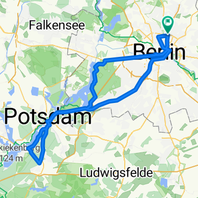
Berliner Mauerweg Nordroute 47,34 Km, vom S-Bhf. Bornholmer Str. nach Spandau, über S-Bhf. Schönholz, Schönfließ, Frohnau, Hennigsdorf, Fähre nach Tegel Ort nach S-Bhf. Tegel.
(cloned from route 289112) (cloned from route 2245238)- -:--
- Duration
- 48.2 km
- Distance
- 120 m
- Ascent
- 134 m
- Descent
- ---
- Avg. speed
- ---
- Max. altitude
Route quality
Waytypes & surfaces along the route
Waytypes
Path
15.9 km
(33 %)
Quiet road
10.6 km
(22 %)
Surfaces
Paved
31.8 km
(66 %)
Unpaved
5.3 km
(11 %)
Asphalt
30.9 km
(64 %)
Ground
3.9 km
(8 %)
Route highlights
Points of interest along the route
Point of interest after 0 km
Startpunkt Brücke S Bhf. Bornholmer Str.
Point of interest after 10.3 km
Pause, schöner Pausenplatz
Point of interest after 24.2 km
Pause, Hubertusklause, sehr gutes Restaurant
Point of interest after 39.7 km
Pause, Wald Restaurante, Badestelle
Continue with Bikemap
Use, edit, or download this cycling route
You would like to ride Berliner Mauerweg Nordroute or customize it for your own trip? Here is what you can do with this Bikemap route:
Free features
- Save this route as favorite or in collections
- Copy & plan your own version of this route
- Sync your route with Garmin or Wahoo
Premium features
Free trial for 3 days, or one-time payment. More about Bikemap Premium.
- Navigate this route on iOS & Android
- Export a GPX / KML file of this route
- Create your custom printout (try it for free)
- Download this route for offline navigation
Discover more Premium features.
Get Bikemap PremiumFrom our community
Other popular routes starting in Gesundbrunnen
 Die Eberswalde Extension 2
- Distance
- 119.3 km
- Ascent
- 342 m
- Descent
- 342 m
- Location
- Gesundbrunnen, State of Berlin, Germany
 Prenzlauer Berg, Mühlenbeck, Blankenfelde
- Distance
- 33.8 km
- Ascent
- 44 m
- Descent
- 46 m
- Location
- Gesundbrunnen, State of Berlin, Germany
 Feierabendrunde für den Norden
- Distance
- 67.1 km
- Ascent
- 61 m
- Descent
- 56 m
- Location
- Gesundbrunnen, State of Berlin, Germany
 Mauerpark > Plötzensee > Jungfernheide > HauptBhf. > Invaliedenfriedhof
- Distance
- 23.6 km
- Ascent
- 51 m
- Descent
- 50 m
- Location
- Gesundbrunnen, State of Berlin, Germany
 Training Nord 60 Lehnitz
- Distance
- 59.3 km
- Ascent
- 166 m
- Descent
- 162 m
- Location
- Gesundbrunnen, State of Berlin, Germany
 Raus aus Berlin, anschlagen und zurück
- Distance
- 96.3 km
- Ascent
- 393 m
- Descent
- 403 m
- Location
- Gesundbrunnen, State of Berlin, Germany
 11Schönhauser Allee Stadtflucht
- Distance
- 47.5 km
- Ascent
- 89 m
- Descent
- 88 m
- Location
- Gesundbrunnen, State of Berlin, Germany
 Berliner Mauerweg Nordroute
- Distance
- 48.5 km
- Ascent
- 123 m
- Descent
- 137 m
- Location
- Gesundbrunnen, State of Berlin, Germany
Open it in the app