

Gallneukirchen-Schneebergerstüber-Gallneukirchen
A cycling route starting in Gallneukirchen, Upper Austria, Austria.
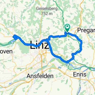
Overview
About this route
short ride to Schneebergerstüberl with a steep climb
- -:--
- Duration
- 25 km
- Distance
- 302 m
- Ascent
- 302 m
- Descent
- ---
- Avg. speed
- ---
- Max. altitude

Route quality
Waytypes & surfaces along the route
Waytypes
Road
14 km
(56 %)
Quiet road
8.5 km
(34 %)
Surfaces
Paved
11 km
(44 %)
Asphalt
11 km
(44 %)
Undefined
14 km
(56 %)
Continue with Bikemap
Use, edit, or download this cycling route
You would like to ride Gallneukirchen-Schneebergerstüber-Gallneukirchen or customize it for your own trip? Here is what you can do with this Bikemap route:
Free features
- Save this route as favorite or in collections
- Copy & plan your own version of this route
- Sync your route with Garmin or Wahoo
Premium features
Free trial for 3 days, or one-time payment. More about Bikemap Premium.
- Navigate this route on iOS & Android
- Export a GPX / KML file of this route
- Create your custom printout (try it for free)
- Download this route for offline navigation
Discover more Premium features.
Get Bikemap PremiumFrom our community
Other popular routes starting in Gallneukirchen
 In de Hockn
- Distance
- 26.1 km
- Ascent
- 72 m
- Descent
- 188 m
- Location
- Gallneukirchen, Upper Austria, Austria
 Lederergasse 50, Gallneukirchen nach Lederergasse 50, Gallneukirchen
- Distance
- 16.7 km
- Ascent
- 435 m
- Descent
- 427 m
- Location
- Gallneukirchen, Upper Austria, Austria
 Gallneukirchen-Steyregg-Gallneukirchen
- Distance
- 37.8 km
- Ascent
- 265 m
- Descent
- 263 m
- Location
- Gallneukirchen, Upper Austria, Austria
 Gallneukirchen - Pregarten - Unterweißenbach - Ruben
- Distance
- 55 km
- Ascent
- 982 m
- Descent
- 512 m
- Location
- Gallneukirchen, Upper Austria, Austria
 Galli - Lamm - Galli
- Distance
- 31.2 km
- Ascent
- 593 m
- Descent
- 593 m
- Location
- Gallneukirchen, Upper Austria, Austria
 Gallneukitchen-Abwinden-Ottensheim-Gallneukirchen
- Distance
- 71.3 km
- Ascent
- 193 m
- Descent
- 193 m
- Location
- Gallneukirchen, Upper Austria, Austria
 Gallneukirchen-Schneebergerstüber-Gallneukirchen
- Distance
- 25 km
- Ascent
- 302 m
- Descent
- 302 m
- Location
- Gallneukirchen, Upper Austria, Austria
 MTB Tour durchs Mühlviertel
- Distance
- 23.4 km
- Ascent
- 456 m
- Descent
- 453 m
- Location
- Gallneukirchen, Upper Austria, Austria
Open it in the app