Schönberg ( einfach )
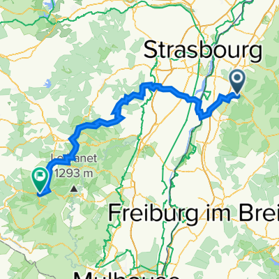
A cycling route starting in Ortenberg, Baden-Wurttemberg, Germany.
Overview
About this route
One time Schönberg and back!
- -:--
- Duration
- 49.2 km
- Distance
- 309 m
- Ascent
- 308 m
- Descent
- ---
- Avg. speed
- ---
- Max. altitude
Route quality
Waytypes & surfaces along the route
Waytypes
Track
10.8 km
(22 %)
Quiet road
9.3 km
(19 %)
Surfaces
Paved
46.2 km
(94 %)
Asphalt
45.3 km
(92 %)
Paved (undefined)
1 km
(2 %)
Undefined
3 km
(6 %)
Continue with Bikemap
Use, edit, or download this cycling route
You would like to ride Schönberg ( einfach ) or customize it for your own trip? Here is what you can do with this Bikemap route:
Free features
- Save this route as favorite or in collections
- Copy & plan your own version of this route
- Sync your route with Garmin or Wahoo
Premium features
Free trial for 3 days, or one-time payment. More about Bikemap Premium.
- Navigate this route on iOS & Android
- Export a GPX / KML file of this route
- Create your custom printout (try it for free)
- Download this route for offline navigation
Discover more Premium features.
Get Bikemap PremiumFrom our community
Other popular routes starting in Ortenberg
Route 1 Elsaßtour (Roller)- Distance
- 156.5 km
- Ascent
- 1,776 m
- Descent
- 1,288 m
- Location
- Ortenberg, Baden-Wurttemberg, Germany
Ofg-Hausach-Gutach-Elzach-Kenzingen-Wyhl-Rust-Schwanau-Ofg- Distance
- 176.3 km
- Ascent
- 969 m
- Descent
- 945 m
- Location
- Ortenberg, Baden-Wurttemberg, Germany
horn- Distance
- 4.3 km
- Ascent
- 468 m
- Descent
- 93 m
- Location
- Ortenberg, Baden-Wurttemberg, Germany
Sattlerweg 2, Offenburg nach Blumenstraße 4A, Hohberg- Distance
- 66.8 km
- Ascent
- 1,157 m
- Descent
- 1,150 m
- Location
- Ortenberg, Baden-Wurttemberg, Germany
Deutschland rundum- Distance
- 350.7 km
- Ascent
- 372 m
- Descent
- 180 m
- Location
- Ortenberg, Baden-Wurttemberg, Germany
Rund ums Geiger Köpfle- Distance
- 41.3 km
- Ascent
- 235 m
- Descent
- 232 m
- Location
- Ortenberg, Baden-Wurttemberg, Germany
Einrolltour 0auf2700 wenig befahrene Straßen- Distance
- 43 km
- Ascent
- 27 m
- Descent
- 31 m
- Location
- Ortenberg, Baden-Wurttemberg, Germany
MTB-Strohbach- Distance
- 30.5 km
- Ascent
- 495 m
- Descent
- 493 m
- Location
- Ortenberg, Baden-Wurttemberg, Germany
Open it in the app


