

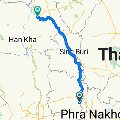
Ang Thong-Chai Nat101
A cycling route starting in Ang Thong, Ang Thong, Thailand.
Overview
About this route
test
- -:--
- Duration
- 101.2 km
- Distance
- 41 m
- Ascent
- 29 m
- Descent
- ---
- Avg. speed
- ---
- Max. altitude
Continue with Bikemap
Use, edit, or download this cycling route
You would like to ride Ang Thong-Chai Nat101 or customize it for your own trip? Here is what you can do with this Bikemap route:
Free features
- Save this route as favorite or in collections
- Copy & plan your own version of this route
- Split it into stages to create a multi-day tour
- Sync your route with Garmin or Wahoo
Premium features
Free trial for 3 days, or one-time payment. More about Bikemap Premium.
- Navigate this route on iOS & Android
- Export a GPX / KML file of this route
- Create your custom printout (try it for free)
- Download this route for offline navigation
Discover more Premium features.
Get Bikemap PremiumFrom our community
Other popular routes starting in Ang Thong
 ตำบล บ้านแห to ตำบล บ้านแห
- Distance
- 35.5 km
- Ascent
- 188 m
- Descent
- 197 m
- Location
- Ang Thong, Ang Thong, Thailand
 ตำบล บ้านแห to Unnamed Road, ตำบล คลองวัว
- Distance
- 33 km
- Ascent
- 132 m
- Descent
- 143 m
- Location
- Ang Thong, Ang Thong, Thailand
 Wat Ton Son-Tak
- Distance
- 364.9 km
- Ascent
- 144 m
- Descent
- 42 m
- Location
- Ang Thong, Ang Thong, Thailand
 Ang Thong-Sing Buri2 45
- Distance
- 43.6 km
- Ascent
- 39 m
- Descent
- 31 m
- Location
- Ang Thong, Ang Thong, Thailand
 Ang Thong - Chainat
- Distance
- 107.3 km
- Ascent
- 101 m
- Descent
- 90 m
- Location
- Ang Thong, Ang Thong, Thailand
 Ang Thong-Chai Nat101
- Distance
- 101.2 km
- Ascent
- 41 m
- Descent
- 29 m
- Location
- Ang Thong, Ang Thong, Thailand
 ตำบล บ้านแห to ตำบล บ้านแห
- Distance
- 28.1 km
- Ascent
- 112 m
- Descent
- 116 m
- Location
- Ang Thong, Ang Thong, Thailand
 Ang Fhong-Sing Buri 45
- Distance
- 45.5 km
- Ascent
- 47 m
- Descent
- 37 m
- Location
- Ang Thong, Ang Thong, Thailand
Open it in the app