

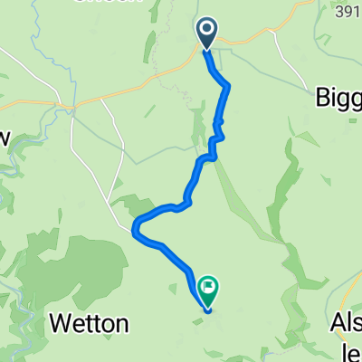
Friden loop
A cycling route starting in Bakewell, England, United Kingdom.
Overview
About this route
Hilly little ride on quiet lanes and a short track
- -:--
- Duration
- 44.7 km
- Distance
- 602 m
- Ascent
- 603 m
- Descent
- ---
- Avg. speed
- ---
- Max. altitude
Route quality
Waytypes & surfaces along the route
Waytypes
Quiet road
26.4 km
(59 %)
Road
12.5 km
(28 %)
Surfaces
Paved
5.8 km
(13 %)
Unpaved
0.4 km
(1 %)
Asphalt
5.8 km
(13 %)
Gravel
0.4 km
(1 %)
Undefined
38.5 km
(86 %)
Continue with Bikemap
Use, edit, or download this cycling route
You would like to ride Friden loop or customize it for your own trip? Here is what you can do with this Bikemap route:
Free features
- Save this route as favorite or in collections
- Copy & plan your own version of this route
- Sync your route with Garmin or Wahoo
Premium features
Free trial for 3 days, or one-time payment. More about Bikemap Premium.
- Navigate this route on iOS & Android
- Export a GPX / KML file of this route
- Create your custom printout (try it for free)
- Download this route for offline navigation
Discover more Premium features.
Get Bikemap PremiumFrom our community
Other popular routes starting in Bakewell
 BAKEWELL PEAK D
- Distance
- 49.5 km
- Ascent
- 974 m
- Descent
- 978 m
- Location
- Bakewell, England, United Kingdom
 Tessington Trails
- Distance
- 42.6 km
- Ascent
- 496 m
- Descent
- 496 m
- Location
- Bakewell, England, United Kingdom
 Bakewell and the Monsal Trail - Bakewell and the Monsal Trail
- Distance
- 29.7 km
- Ascent
- 608 m
- Descent
- 609 m
- Location
- Bakewell, England, United Kingdom
 Pilhough Lane to Butts Road
- Distance
- 9.8 km
- Ascent
- 147 m
- Descent
- 271 m
- Location
- Bakewell, England, United Kingdom
 Bakewell - Parsley Hey
- Distance
- 32.6 km
- Ascent
- 444 m
- Descent
- 444 m
- Location
- Bakewell, England, United Kingdom
 BAKEWELL
- Distance
- 32.8 km
- Ascent
- 517 m
- Descent
- 516 m
- Location
- Bakewell, England, United Kingdom
 Church Street to Church Lane
- Distance
- 6.8 km
- Ascent
- 183 m
- Descent
- 140 m
- Location
- Bakewell, England, United Kingdom
 Monsal Trail, Hassop, Bakewell to 27 Riverside Cresent, Bakewell
- Distance
- 26.4 km
- Ascent
- 231 m
- Descent
- 269 m
- Location
- Bakewell, England, United Kingdom
Open it in the app