HIRMES
- 93.4 km
- 1,110 m
- 1,110 m
- Aguadulce, Andalusia, Spain
A cycling route starting in Aguadulce, Andalusia, Spain.
Overview
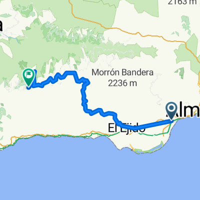
Road route.- From AGUADULCE-EL PARADOR, we climb up to ENIX and cross the village, continuing to the end of the road where the descent to Almería begins along the stony path. This is the highest point where we turn around.
created this 16 years ago
Route quality
Track
13.5 km
(26 %)
Quiet road
9.3 km
(18 %)
Paved
6.7 km
(13 %)
Unpaved
5.2 km
(10 %)
Asphalt
6.7 km
(13 %)
Unpaved (undefined)
4.7 km
(9 %)
Route highlights
punto de posible retorno
Continue with Bikemap
You would like to ride AGUADULCE-ENIX-caseta Militares or customize it for your own trip? Here is what you can do with this Bikemap route:
Free trial for 3 days, or one-time payment. More about Bikemap Premium.
Discover more Premium features.
Get Bikemap PremiumFrom our community
Open it in the app