

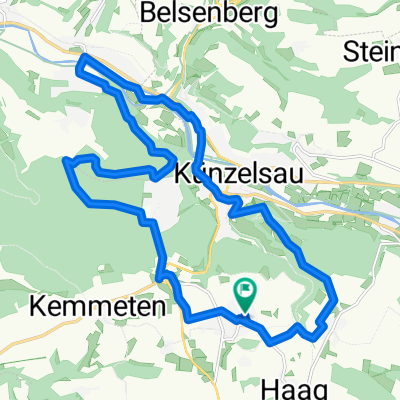
Jagst-Kocher Seitentäler / Hohenloher Ebene
A cycling route starting in Künzelsau, Baden-Wurttemberg, Germany.
Overview
About this route
Scenic tour
(cloned from route 76434)- -:--
- Duration
- 27.5 km
- Distance
- 350 m
- Ascent
- 351 m
- Descent
- ---
- Avg. speed
- ---
- Max. altitude

Route quality
Waytypes & surfaces along the route
Waytypes
Track
12.4 km
(45 %)
Quiet road
8.8 km
(32 %)
Surfaces
Paved
9.9 km
(36 %)
Unpaved
6.3 km
(23 %)
Paved (undefined)
8.5 km
(31 %)
Gravel
3 km
(11 %)
Continue with Bikemap
Use, edit, or download this cycling route
You would like to ride Jagst-Kocher Seitentäler / Hohenloher Ebene or customize it for your own trip? Here is what you can do with this Bikemap route:
Free features
- Save this route as favorite or in collections
- Copy & plan your own version of this route
- Sync your route with Garmin or Wahoo
Premium features
Free trial for 3 days, or one-time payment. More about Bikemap Premium.
- Navigate this route on iOS & Android
- Export a GPX / KML file of this route
- Create your custom printout (try it for free)
- Download this route for offline navigation
Discover more Premium features.
Get Bikemap PremiumFrom our community
Other popular routes starting in Künzelsau
 Jagst-Radweg und historische Hohe Straße
- Distance
- 138.4 km
- Ascent
- 1,535 m
- Descent
- 1,585 m
- Location
- Künzelsau, Baden-Wurttemberg, Germany
 Kocherstetten (37,7 km)
- Distance
- 38.1 km
- Ascent
- 620 m
- Descent
- 620 m
- Location
- Künzelsau, Baden-Wurttemberg, Germany
 BSG STAHL Abschlußfahrt 09
- Distance
- 45.7 km
- Ascent
- 820 m
- Descent
- 756 m
- Location
- Künzelsau, Baden-Wurttemberg, Germany
 Kupfertalrunde
- Distance
- 39.7 km
- Ascent
- 483 m
- Descent
- 483 m
- Location
- Künzelsau, Baden-Wurttemberg, Germany
 Döttingen-Künzelsau
- Distance
- 19.1 km
- Ascent
- 174 m
- Descent
- 184 m
- Location
- Künzelsau, Baden-Wurttemberg, Germany
 Jagst-Kocher Seitentäler / Hohenloher Ebene
- Distance
- 27.5 km
- Ascent
- 350 m
- Descent
- 351 m
- Location
- Künzelsau, Baden-Wurttemberg, Germany
 künzelsauer Runde 2
- Distance
- 20.6 km
- Ascent
- 316 m
- Descent
- 316 m
- Location
- Künzelsau, Baden-Wurttemberg, Germany
 Schöne Trainingsrunde in ziemlich ruhiger Gegend
- Distance
- 88.5 km
- Ascent
- 948 m
- Descent
- 851 m
- Location
- Künzelsau, Baden-Wurttemberg, Germany
Open it in the app