5 salite
- 82 km
- 1,001 m
- 1,004 m
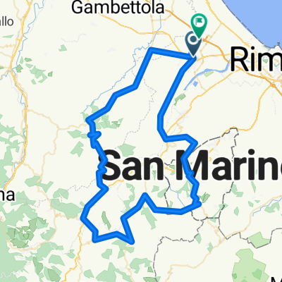
- Santarcangelo di Romagna, Emilia-Romagna, Italy
A cycling route starting in Santarcangelo di Romagna, Emilia-Romagna, Italy.
Overview
Route from Santarcangelo in the valley floor up to the Verucchio bridge, then climb to Montetiffi and descent on the other side. Asphalt up to this point.
The route ascends again passing near the Romanesque bridge and climbing along a gravel dirt road leading to the hills of Massamanente, then back to asphalt descending to the fork at Passo del Grillo and returning again to the valley floor.
Very beautiful scenery on the Massamanente ridge.
created this 11 years ago
Route quality
Road
35.3 km
(62 %)
Quiet road
19.4 km
(34 %)
Paved
29.1 km
(51 %)
Unpaved
4 km
(7 %)
Asphalt
29.1 km
(51 %)
Gravel
4 km
(7 %)
Undefined
23.9 km
(42 %)
Continue with Bikemap
You would like to ride Santarcangelo Montetiffi Massamanente or customize it for your own trip? Here is what you can do with this Bikemap route:
Free trial for 3 days, or one-time payment. More about Bikemap Premium.
Discover more Premium features.
Get Bikemap PremiumFrom our community
Open it in the app