

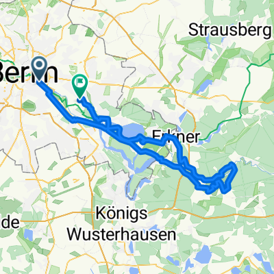
Berlin Mitte - Werneuchen - Müncheberg - Fürstenwalde - Hartmannsdorf - Neu-Zittau - Adlershof - Berlin Mitte
A cycling route starting in Berlin Treptow, Land Berlin, Germany.
Overview
About this route
Erster Versuch Granfondo 160km, leider etwas zu kurz
- -:--
- Duration
- 154.3 km
- Distance
- 201 m
- Ascent
- 201 m
- Descent
- ---
- Avg. speed
- ---
- Avg. speed

Route quality
Waytypes & surfaces along the route
Waytypes
Busy road
60.8 km
(39 %)
Road
29.4 km
(19 %)
Surfaces
Paved
142.9 km
(93 %)
Unpaved
3.4 km
(2 %)
Asphalt
122.5 km
(79 %)
Paving stones
14 km
(9 %)
Continue with Bikemap
Use, edit, or download this cycling route
You would like to ride Berlin Mitte - Werneuchen - Müncheberg - Fürstenwalde - Hartmannsdorf - Neu-Zittau - Adlershof - Berlin Mitte or customize it for your own trip? Here is what you can do with this Bikemap route:
Free features
- Save this route as favorite or in collections
- Copy & plan your own version of this route
- Split it into stages to create a multi-day tour
- Sync your route with Garmin or Wahoo
Premium features
Free trial for 3 days, or one-time payment. More about Bikemap Premium.
- Navigate this route on iOS & Android
- Export a GPX / KML file of this route
- Create your custom printout (try it for free)
- Download this route for offline navigation
Discover more Premium features.
Get Bikemap PremiumFrom our community
Other popular routes starting in Berlin Treptow
 Spreewiesentour
- Distance
- 86.3 km
- Ascent
- 228 m
- Descent
- 222 m
- Location
- Berlin Treptow, Land Berlin, Germany
 Berlin-Darmstadt Rennrad
- Distance
- 558.2 km
- Ascent
- 1,417 m
- Descent
- 1,315 m
- Location
- Berlin Treptow, Land Berlin, Germany
 nah am wasser gebaut
- Distance
- 15 km
- Ascent
- 19 m
- Descent
- 32 m
- Location
- Berlin Treptow, Land Berlin, Germany
 East Side Gallery – Rathaus Spandau
- Distance
- 25.9 km
- Ascent
- 92 m
- Descent
- 88 m
- Location
- Berlin Treptow, Land Berlin, Germany
 Feierabendrunde: Berlin-KW-Berlin
- Distance
- 43.3 km
- Ascent
- 47 m
- Descent
- 47 m
- Location
- Berlin Treptow, Land Berlin, Germany
 Privat Etappe 2
- Distance
- 37.2 km
- Ascent
- 75 m
- Descent
- 69 m
- Location
- Berlin Treptow, Land Berlin, Germany
 F'hain - Schöneweide - Gropiusstadt - Neukölln - F'hain
- Distance
- 26.4 km
- Ascent
- 31 m
- Descent
- 15 m
- Location
- Berlin Treptow, Land Berlin, Germany
 Hermannplatz – Schildhorn
- Distance
- 41.2 km
- Ascent
- 130 m
- Descent
- 132 m
- Location
- Berlin Treptow, Land Berlin, Germany
Open it in the app