RUB6_Altdöbern_Sauen
- 127.5 km
- 93 m
- 117 m
- Altdöbern, Brandenburg, Germany
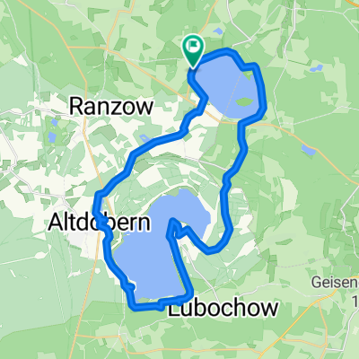
A cycling route starting in Altdöbern, Brandenburg, Germany.
Overview
Start and finish at the diving school Laasow at Gräbendorfer Lake, first follow the signage 'Pücklerweg' in the direction of Reddern along Gräbendorfer Lake. In Reddern, stay on the road and go over Peitzendorf to Altdöbern. Worth seeing: castle and small baroque garden, unfortunately in a regrettable state. At the market, turn towards the clinic and continue always on the cycle path along the future Altdöberner Lake. Various viewpoints up to Pritzen. In Pritzen on weekends, dining is available at the village inn. After Pritzen, continue towards Göritz, Casel over the Hochkippe (12% incline and then again 12% decline). At the western edge of Casel, switch to the circular route around Gräbendorfer Lake. Notes: Between Reddern and Altdöbern, poorly trafficked country road, otherwise independent paved bike paths. Signage (Apr. 2008) poor. Dining at the diving school Laasow, Pritzen, Casel, at the market in Altdöbern no restaurant! (Apr. 2008) Route recorded with Nokia Sportstracker
Route quality
Path
9.6 km
(28 %)
Cycleway
9.3 km
(27 %)
Paved
31.3 km
(91 %)
Unpaved
1.4 km
(4 %)
Asphalt
31.3 km
(91 %)
Unpaved (undefined)
1 km
(3 %)
Route highlights
Tauchschule Laasow
Aussichtspunkt, leider an der Weggabelung keine Ausschilderung
12% Steigung in Richtung Norden
12% Gefälle in Richtung Norden
Streckenvariante: abbiegen nach links um den Gräbendorfer See
Continue with Bikemap
You would like to ride Gräbendorfer und Altdöberner See or customize it for your own trip? Here is what you can do with this Bikemap route:
Free trial for 3 days, or one-time payment. More about Bikemap Premium.
Discover more Premium features.
Get Bikemap PremiumFrom our community
Open it in the app