

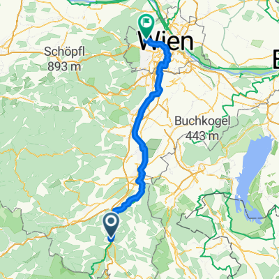
Dreiländreck NÖ - B - Stm.
A cycling route starting in Grimmenstein, Lower Austria, Austria.
Overview
About this route
Grimmenstein - Edlitz - Thomasberg - Krumbach - Kirchschlag - Bernstein - Mariasdorf - Oberschützen - Pinkafeld - Dechantskirchen - Friedberg - Mönichkirchen - Grimmenstein
- -:--
- Duration
- 105 km
- Distance
- 1,685 m
- Ascent
- 1,682 m
- Descent
- ---
- Avg. speed
- ---
- Max. altitude

Route quality
Waytypes & surfaces along the route
Waytypes
Road
21 km
(20 %)
Quiet road
3.2 km
(3 %)
Surfaces
Paved
49.4 km
(47 %)
Asphalt
49.4 km
(47 %)
Undefined
55.7 km
(53 %)
Continue with Bikemap
Use, edit, or download this cycling route
You would like to ride Dreiländreck NÖ - B - Stm. or customize it for your own trip? Here is what you can do with this Bikemap route:
Free features
- Save this route as favorite or in collections
- Copy & plan your own version of this route
- Split it into stages to create a multi-day tour
- Sync your route with Garmin or Wahoo
Premium features
Free trial for 3 days, or one-time payment. More about Bikemap Premium.
- Navigate this route on iOS & Android
- Export a GPX / KML file of this route
- Create your custom printout (try it for free)
- Download this route for offline navigation
Discover more Premium features.
Get Bikemap PremiumFrom our community
Other popular routes starting in Grimmenstein
 Gleißenfeld - ThermenRadweg - Feistritztalradweg - Schwarzatal Radweg - Ternitz
- Distance
- 40.4 km
- Ascent
- 554 m
- Descent
- 619 m
- Location
- Grimmenstein, Lower Austria, Austria
 Petersbaumgarten-Hochegg-Rams-Turach-Kals
- Distance
- 401.6 km
- Ascent
- 2,983 m
- Descent
- 2,047 m
- Location
- Grimmenstein, Lower Austria, Austria
 Grimmenstein Tour
- Distance
- 34 km
- Ascent
- 32 m
- Descent
- 167 m
- Location
- Grimmenstein, Lower Austria, Austria
 Runradeln mit Burgen und Höhle
- Distance
- 44.7 km
- Ascent
- 1,102 m
- Descent
- 859 m
- Location
- Grimmenstein, Lower Austria, Austria
 Route to Austria Trend Hotel Schloss Wilhelminenberg
- Distance
- 101.5 km
- Ascent
- 488 m
- Descent
- 536 m
- Location
- Grimmenstein, Lower Austria, Austria
 grim-bs
- Distance
- 18 km
- Ascent
- 272 m
- Descent
- 219 m
- Location
- Grimmenstein, Lower Austria, Austria
 Grimmenstein - Kirchschlag
- Distance
- 26.1 km
- Ascent
- 360 m
- Descent
- 354 m
- Location
- Grimmenstein, Lower Austria, Austria
 Mönichkirchen Schwaig
- Distance
- 95.7 km
- Ascent
- 1,938 m
- Descent
- 1,938 m
- Location
- Grimmenstein, Lower Austria, Austria
Open it in the app