

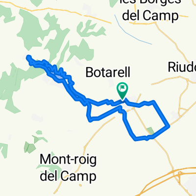
ruta 48 de cicloturisme per Catalunya
A cycling route starting in Botarell, Catalonia, Spain.
Overview
About this route
for the lands of the csrtoixans
- -:--
- Duration
- 114.4 km
- Distance
- 1,589 m
- Ascent
- 1,590 m
- Descent
- ---
- Avg. speed
- ---
- Max. altitude

Route quality
Waytypes & surfaces along the route
Waytypes
Road
76.6 km
(67 %)
Track
1.1 km
(1 %)
Undefined
36.6 km
(32 %)
Surfaces
Paved
10.3 km
(9 %)
Asphalt
10.3 km
(9 %)
Undefined
104.1 km
(91 %)
Continue with Bikemap
Use, edit, or download this cycling route
You would like to ride ruta 48 de cicloturisme per Catalunya or customize it for your own trip? Here is what you can do with this Bikemap route:
Free features
- Save this route as favorite or in collections
- Copy & plan your own version of this route
- Split it into stages to create a multi-day tour
- Sync your route with Garmin or Wahoo
Premium features
Free trial for 3 days, or one-time payment. More about Bikemap Premium.
- Navigate this route on iOS & Android
- Export a GPX / KML file of this route
- Create your custom printout (try it for free)
- Download this route for offline navigation
Discover more Premium features.
Get Bikemap PremiumFrom our community
Other popular routes starting in Botarell
 Volta al Priorat'22. MUSSARA-MORERA DE MONTSANT-COLLDEJOU-MARE DE DÉU DE LA ROCA-CASTELL D'ESCORNALBOU.
- Distance
- 130.5 km
- Ascent
- 2,973 m
- Descent
- 2,973 m
- Location
- Botarell, Catalonia, Spain
 ruta 48 de cicloturisme per Catalunya
- Distance
- 114.4 km
- Ascent
- 1,589 m
- Descent
- 1,590 m
- Location
- Botarell, Catalonia, Spain
 montroig escornalbou porrera colldejou
- Distance
- 72.5 km
- Ascent
- 1,236 m
- Descent
- 1,241 m
- Location
- Botarell, Catalonia, Spain
 montbrio del camp 2
- Distance
- 75.1 km
- Ascent
- 914 m
- Descent
- 914 m
- Location
- Botarell, Catalonia, Spain
 Montbrió-Riudecanyes
- Distance
- 26.7 km
- Ascent
- 215 m
- Descent
- 215 m
- Location
- Botarell, Catalonia, Spain
 Etapa larga con mas desnivel. 237 km + 4860+
- Distance
- 236.6 km
- Ascent
- 3,732 m
- Descent
- 3,678 m
- Location
- Botarell, Catalonia, Spain
 montbrió del camp
- Distance
- 121.9 km
- Ascent
- 1,601 m
- Descent
- 1,594 m
- Location
- Botarell, Catalonia, Spain
 Route 64
- Distance
- 64.3 km
- Ascent
- 1,324 m
- Descent
- 1,322 m
- Location
- Botarell, Catalonia, Spain
Open it in the app