

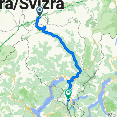
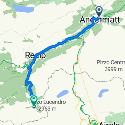
Rhein-Radweg
A cycling route starting in Andermatt, Canton of Uri, Switzerland.
Overview
About this route
The Rhine Cycle Route (EV15 EuroVelo 15) is a long-distance cycle path of about 1,350 km that runs through five countries from the source of the Rhine in the Swiss Alps at the Oberalp Pass to its mouth at Rotterdam. The first approximately 430 km of the Rhine Cycle Route runs in Switzerland up to Basel, only partially along the banks of the Vorder Rhine, the Alpine Rhine, and the High Rhine, marked as the Rhine Route with number 2. A small section from St. Margrethen to Rheineck runs through Austria. The second approximately 385 km long Upper Rhine section of the Rhine Cycle Route is guided through the Upper Rhine Plain and the Mainz Basin. Here, one can choose to ride on the left bank in France or on the right bank in Germany between Alsace / the Vosges and the Black Forest. The third 132 km section of the Rhine Cycle Route runs along the Rhine through the Middle Rhine Valley from Bingen to Bonn. The left bank section between Bingen and Koblenz, shaped by castles, through the Rhine Slate Mountains is particularly impressive. The fourth section, about 460 km long, of the Rhine Cycle Route runs along the Lower Rhine from Bonn to Rotterdam. From Bonn via Cologne and Düsseldorf to Duisburg runs the experience path Rheinschiene. In the Netherlands, routes along the Waal or along the Nederrijn and Leks to the Rhine estuary at Rotterdam are possible.
More information at http://www.rheinradweg.net/
The text and image material used here comes from Wikipedia.
Suitable travel guides: Kompass: Rhine Cycle Route 1 - ISBN: 978-3-8502-6642-0
- -:--
- Duration
- 1,356.7 km
- Distance
- 171 m
- Ascent
- 1,603 m
- Descent
- ---
- Avg. speed
- ---
- Max. altitude

Route quality
Waytypes & surfaces along the route
Waytypes
Quiet road
339.2 km
(25 %)
Track
339.2 km
(25 %)
Surfaces
Paved
963.2 km
(71 %)
Unpaved
176.4 km
(13 %)
Asphalt
922.5 km
(68 %)
Gravel
149.2 km
(11 %)
Route highlights
Points of interest along the route

Point of interest after 295.1 km
Der Rheinfall ist der größte Wasserfall Europas, neben dem doppelt so hohen, aber halb so wasserreichen Dettifoss auf Island. Er befindet sich in der Schweiz auf dem Gebiet der Gemeinden Neuhausen am Rheinfall im Kanton Schaffhausen (rechtsufrig) und Laufen-Uhwiesen im Kanton Zürich (linksufrig), rund vier Kilometer westlich unterhalb der Stadt Schaffhausen. Der Rheinfall hat eine Höhe von 23 Metern und eine Breite von 150 Metern. Man kann sich mit Ausflugsbooten dicht an den Rheinfall heranfahren und am mittleren Felsen absetzen lassen. Die Besteigung der Aussichtsplattform mit atemberaubender Sicht auf den Fall erfolgt über schmale und steile Treppen.
Continue with Bikemap
Use, edit, or download this cycling route
You would like to ride Rhein-Radweg or customize it for your own trip? Here is what you can do with this Bikemap route:
Free features
- Save this route as favorite or in collections
- Copy & plan your own version of this route
- Split it into stages to create a multi-day tour
- Sync your route with Garmin or Wahoo
Premium features
Free trial for 3 days, or one-time payment. More about Bikemap Premium.
- Navigate this route on iOS & Android
- Export a GPX / KML file of this route
- Create your custom printout (try it for free)
- Download this route for offline navigation
Discover more Premium features.
Get Bikemap PremiumFrom our community
Other popular routes starting in Andermatt
 Furka-Nufenen-Gotthard-Oberalp
- Distance
- 135.9 km
- Ascent
- 4,637 m
- Descent
- 4,527 m
- Location
- Andermatt, Canton of Uri, Switzerland
 giro dei tre passi susten grimsel furka
- Distance
- 132.9 km
- Ascent
- 3,457 m
- Descent
- 3,601 m
- Location
- Andermatt, Canton of Uri, Switzerland
 Bellinzona - Vizzola Ticino
- Distance
- 130.7 km
- Ascent
- 2,639 m
- Descent
- 3,799 m
- Location
- Andermatt, Canton of Uri, Switzerland
![[DAY 19] Göschenen - Ilanz](https://media.bikemap.net/routes/8561780/gallery/thumbs/af10c4bc-a85d-4013-8c11-c6c25ccc528a.jpeg.208x208_q80_crop.jpg) [DAY 19] Göschenen - Ilanz
[DAY 19] Göschenen - Ilanz- Distance
- 68.1 km
- Ascent
- 984 m
- Descent
- 1,380 m
- Location
- Andermatt, Canton of Uri, Switzerland
 20.09.2010 Furka, Nufenen, Gotthard
- Distance
- 98.5 km
- Ascent
- 2,959 m
- Descent
- 2,959 m
- Location
- Andermatt, Canton of Uri, Switzerland
 Witenwasseren Bike
- Distance
- 17.3 km
- Ascent
- 808 m
- Descent
- 26 m
- Location
- Andermatt, Canton of Uri, Switzerland
 Andermatt 3
- Distance
- 158.9 km
- Ascent
- 3,905 m
- Descent
- 3,702 m
- Location
- Andermatt, Canton of Uri, Switzerland
 Transalpine (7) Andermatt - Visp
- Distance
- 89.5 km
- Ascent
- 1,685 m
- Descent
- 2,290 m
- Location
- Andermatt, Canton of Uri, Switzerland
Open it in the app