

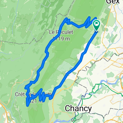
Crozet, Col du Marchairuz
A cycling route starting in Chevry, Auvergne-Rhône-Alpes, France.
Overview
About this route
'Shortest' possible route from Crozet to Marchairuz via Col de la Faucille
- -:--
- Duration
- 109.4 km
- Distance
- 1,343 m
- Ascent
- 1,343 m
- Descent
- ---
- Avg. speed
- ---
- Max. altitude

Route photos

Route quality
Waytypes & surfaces along the route
Waytypes
Road
53.6 km
(49 %)
Busy road
52.4 km
(48 %)
Surfaces
Paved
64.5 km
(59 %)
Asphalt
64.5 km
(59 %)
Undefined
44.9 km
(41 %)
Continue with Bikemap
Use, edit, or download this cycling route
You would like to ride Crozet, Col du Marchairuz or customize it for your own trip? Here is what you can do with this Bikemap route:
Free features
- Save this route as favorite or in collections
- Copy & plan your own version of this route
- Split it into stages to create a multi-day tour
- Sync your route with Garmin or Wahoo
Premium features
Free trial for 3 days, or one-time payment. More about Bikemap Premium.
- Navigate this route on iOS & Android
- Export a GPX / KML file of this route
- Create your custom printout (try it for free)
- Download this route for offline navigation
Discover more Premium features.
Get Bikemap PremiumFrom our community
Other popular routes starting in Chevry
 Chevry à Petit Lancy
- Distance
- 23.6 km
- Ascent
- 141 m
- Descent
- 218 m
- Location
- Chevry, Auvergne-Rhône-Alpes, France
 Short morning ride
- Distance
- 43.4 km
- Ascent
- 182 m
- Descent
- 181 m
- Location
- Chevry, Auvergne-Rhône-Alpes, France
 Col de Crozet - Lélex - Col du Sac (projet)
- Distance
- 71.5 km
- Ascent
- 1,736 m
- Descent
- 1,736 m
- Location
- Chevry, Auvergne-Rhône-Alpes, France
 Mollendruz, Vallée de Joux
- Distance
- 141.3 km
- Ascent
- 1,172 m
- Descent
- 1,174 m
- Location
- Chevry, Auvergne-Rhône-Alpes, France
 Chevry à Petit Lancy #2
- Distance
- 16.8 km
- Ascent
- 109 m
- Descent
- 185 m
- Location
- Chevry, Auvergne-Rhône-Alpes, France
 TGV2018 - ETAPE 0 : Genève-Aigle
- Distance
- 135.9 km
- Ascent
- 2,073 m
- Descent
- 2,120 m
- Location
- Chevry, Auvergne-Rhône-Alpes, France
 Val de valserine
- Distance
- 104.8 km
- Ascent
- 1,313 m
- Descent
- 1,313 m
- Location
- Chevry, Auvergne-Rhône-Alpes, France
 Ete 2016 (PROJET)
- Distance
- 1,197.2 km
- Ascent
- 10,715 m
- Descent
- 10,737 m
- Location
- Chevry, Auvergne-Rhône-Alpes, France
Open it in the app