

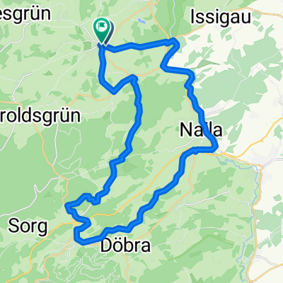
Radtour mit vielen Höhenmetern
A cycling route starting in Bad Steben, Bavaria, Germany.
Overview
About this route
Always asphalt. Often narrow and winding descents. Climbs of up to 19 %.
- -:--
- Duration
- 105.6 km
- Distance
- 1,956 m
- Ascent
- 2,020 m
- Descent
- ---
- Avg. speed
- 690 m
- Max. altitude
Route quality
Waytypes & surfaces along the route
Waytypes
Quiet road
31.7 km
(30 %)
Road
30.6 km
(29 %)
Surfaces
Paved
43.3 km
(41 %)
Unpaved
17.9 km
(17 %)
Asphalt
42.2 km
(40 %)
Gravel
12.7 km
(12 %)
Continue with Bikemap
Use, edit, or download this cycling route
You would like to ride Radtour mit vielen Höhenmetern or customize it for your own trip? Here is what you can do with this Bikemap route:
Free features
- Save this route as favorite or in collections
- Copy & plan your own version of this route
- Split it into stages to create a multi-day tour
- Sync your route with Garmin or Wahoo
Premium features
Free trial for 3 days, or one-time payment. More about Bikemap Premium.
- Navigate this route on iOS & Android
- Export a GPX / KML file of this route
- Create your custom printout (try it for free)
- Download this route for offline navigation
Discover more Premium features.
Get Bikemap PremiumFrom our community
Other popular routes starting in Bad Steben
 Radtour mit vielen Höhenmetern
- Distance
- 105.6 km
- Ascent
- 1,956 m
- Descent
- 2,020 m
- Location
- Bad Steben, Bavaria, Germany
 2010 Thüringen, Ostbayern, Böhmen Tag 4
- Distance
- 25.9 km
- Ascent
- 486 m
- Descent
- 457 m
- Location
- Bad Steben, Bavaria, Germany
 Bad Steben - Mörlareuth
- Distance
- 25.4 km
- Ascent
- 504 m
- Descent
- 526 m
- Location
- Bad Steben, Bavaria, Germany
 Frankenrundfahrt
- Distance
- 107.3 km
- Ascent
- 1,650 m
- Descent
- 1,677 m
- Location
- Bad Steben, Bavaria, Germany
 Die kleine Einführungsrunde
- Distance
- 15.6 km
- Ascent
- 218 m
- Descent
- 185 m
- Location
- Bad Steben, Bavaria, Germany
 Tour_zur_Kur_HO_12
- Distance
- 34.5 km
- Ascent
- 467 m
- Descent
- 465 m
- Location
- Bad Steben, Bavaria, Germany
 Steinige Tour (Schleife 1)
- Distance
- 20.5 km
- Ascent
- 291 m
- Descent
- 297 m
- Location
- Bad Steben, Bavaria, Germany
 Blankenstein - Redwitz an der Rodach
- Distance
- 56.6 km
- Ascent
- 450 m
- Descent
- 758 m
- Location
- Bad Steben, Bavaria, Germany
Open it in the app