
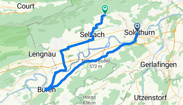
Solothurn-Arch-Büren-Staad-Grenchen-Selzach-Im Holz
A cycling route starting in Solothurn, Canton of Solothurn, Switzerland.
Overview
About this route
Solothurn-Arch-Büren-Staad-Grenchen-Selzach-Im Holz
- -:--
- Duration
- 32.6 km
- Distance
- 252 m
- Ascent
- 83 m
- Descent
- ---
- Avg. speed
- ---
- Max. altitude
Route quality
Waytypes & surfaces along the route
Waytypes
Busy road
13.7 km
(42 %)
Quiet road
9.8 km
(30 %)
Surfaces
Paved
15.5 km
(48 %)
Unpaved
0 km
(<1 %)
Asphalt
14.9 km
(46 %)
Paved (undefined)
0.4 km
(1 %)
Continue with Bikemap
Use, edit, or download this cycling route
You would like to ride Solothurn-Arch-Büren-Staad-Grenchen-Selzach-Im Holz or customize it for your own trip? Here is what you can do with this Bikemap route:
Free features
- Save this route as favorite or in collections
- Copy & plan your own version of this route
- Sync your route with Garmin or Wahoo
Premium features
Free trial for 3 days, or one-time payment. More about Bikemap Premium.
- Navigate this route on iOS & Android
- Export a GPX / KML file of this route
- Create your custom printout (try it for free)
- Download this route for offline navigation
Discover more Premium features.
Get Bikemap PremiumFrom our community
Other popular routes starting in Solothurn
 Von Solothurn bis Hünenberg
- Distance
- 113.2 km
- Ascent
- 954 m
- Descent
- 944 m
- Location
- Solothurn, Canton of Solothurn, Switzerland
 Solothurn - Bucheggberg - Solothurn
- Distance
- 50 km
- Ascent
- 249 m
- Descent
- 244 m
- Location
- Solothurn, Canton of Solothurn, Switzerland
 Tag 1.2 Solothurn-Noiraigue
- Distance
- 80.4 km
- Ascent
- 756 m
- Descent
- 424 m
- Location
- Solothurn, Canton of Solothurn, Switzerland
 35.Radtour 18 1a. Teil
- Distance
- 21 km
- Ascent
- 59 m
- Descent
- 27 m
- Location
- Solothurn, Canton of Solothurn, Switzerland
 Moll-Treff 2025
- Distance
- 10.2 km
- Ascent
- 23 m
- Descent
- 23 m
- Location
- Solothurn, Canton of Solothurn, Switzerland
 Vorberg, Weissenstein
- Distance
- 20.6 km
- Ascent
- 555 m
- Descent
- 551 m
- Location
- Solothurn, Canton of Solothurn, Switzerland
 Feierabendtour Richtung Balmberg
- Distance
- 19.4 km
- Ascent
- 1,025 m
- Descent
- 1,013 m
- Location
- Solothurn, Canton of Solothurn, Switzerland
 2-Solothurn-Lörrach-77km-130Hm
- Distance
- 77.3 km
- Ascent
- 887 m
- Descent
- 962 m
- Location
- Solothurn, Canton of Solothurn, Switzerland
Open it in the app