

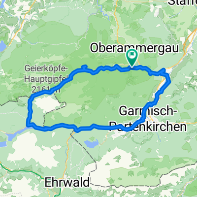
Ettal-Wallgau-Bayrischzell-Kössen-Bad Reichenhall
A cycling route starting in Ettal, Bavaria, Germany.
Overview
About this route
längere schöne Alpen Etappe
- -:--
- Duration
- 206.8 km
- Distance
- 1,424 m
- Ascent
- 1,828 m
- Descent
- ---
- Avg. speed
- ---
- Max. altitude

Route quality
Waytypes & surfaces along the route
Waytypes
Busy road
157.1 km
(76 %)
Quiet road
21.7 km
(10 %)
Surfaces
Paved
200.6 km
(97 %)
Unpaved
3.6 km
(2 %)
Asphalt
198.9 km
(96 %)
Paved (undefined)
1.1 km
(<1 %)
Continue with Bikemap
Use, edit, or download this cycling route
You would like to ride Ettal-Wallgau-Bayrischzell-Kössen-Bad Reichenhall or customize it for your own trip? Here is what you can do with this Bikemap route:
Free features
- Save this route as favorite or in collections
- Copy & plan your own version of this route
- Split it into stages to create a multi-day tour
- Sync your route with Garmin or Wahoo
Premium features
Free trial for 3 days, or one-time payment. More about Bikemap Premium.
- Navigate this route on iOS & Android
- Export a GPX / KML file of this route
- Create your custom printout (try it for free)
- Download this route for offline navigation
Discover more Premium features.
Get Bikemap PremiumFrom our community
Other popular routes starting in Ettal
 5) Ettal - Schwangau
- Distance
- 51.6 km
- Ascent
- 447 m
- Descent
- 518 m
- Location
- Ettal, Bavaria, Germany
 Fernradweg - Ammer Amper Radweg - Fernradweg - Ammer Amper Radweg
- Distance
- 202.9 km
- Ascent
- 612 m
- Descent
- 1,035 m
- Location
- Ettal, Bavaria, Germany
 Linderhof Ride
- Distance
- 24.2 km
- Ascent
- 346 m
- Descent
- 343 m
- Location
- Ettal, Bavaria, Germany
 Ueber den Baeckenalmsattel zur Kenzenhuette
- Distance
- 59 km
- Ascent
- 1,005 m
- Descent
- 1,004 m
- Location
- Ettal, Bavaria, Germany
 Ettal-Wallgau-Bayrischzell-Kössen-Bad Reichenhall
- Distance
- 206.8 km
- Ascent
- 1,424 m
- Descent
- 1,828 m
- Location
- Ettal, Bavaria, Germany
 Ammer-Amper-Radweg
- Distance
- 190.7 km
- Ascent
- 1,181 m
- Descent
- 1,582 m
- Location
- Ettal, Bavaria, Germany
 Garmisch-Partenkirchen
- Distance
- 67.7 km
- Ascent
- 518 m
- Descent
- 517 m
- Location
- Ettal, Bavaria, Germany
 Ettal - Ennigalm - Brunnenkopf
- Distance
- 64.2 km
- Ascent
- 1,691 m
- Descent
- 1,695 m
- Location
- Ettal, Bavaria, Germany
Open it in the app