

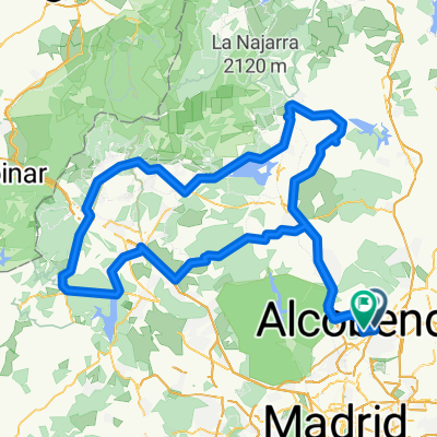
Alcobendas-Cerceda-Soto-Urb.Rancajales-Colmenar-Alcobendas
A cycling route starting in Alcobendas, Madrid, Spain.
Overview
About this route
Salida tranquila de Alcobendas, seguimos por el carril bici y cogemos desvío dirección Cerceda. Seguimos hasta Cerceda, giramos a la derecha pasando por Manzanares y llegando a Soto (parada técnica café, barrita...) salimos direcciona Miraflores y cogemos glorieta a la derecha por la carretera de circunvalación. Seguimos y nos desviamos por la Urb.Los Rancajales. Subida del muro (pequeña cima de 2,8Kms con pendientes entre el 10% y 12%). Coronamos con vistas maravillosas y bajamos hasta Colmenar. Continuamos ya por el carril bici y vuelta a casa.
- -:--
- Duration
- 88.4 km
- Distance
- 629 m
- Ascent
- 628 m
- Descent
- ---
- Avg. speed
- ---
- Max. altitude
Continue with Bikemap
Use, edit, or download this cycling route
You would like to ride Alcobendas-Cerceda-Soto-Urb.Rancajales-Colmenar-Alcobendas or customize it for your own trip? Here is what you can do with this Bikemap route:
Free features
- Save this route as favorite or in collections
- Copy & plan your own version of this route
- Split it into stages to create a multi-day tour
- Sync your route with Garmin or Wahoo
Premium features
Free trial for 3 days, or one-time payment. More about Bikemap Premium.
- Navigate this route on iOS & Android
- Export a GPX / KML file of this route
- Create your custom printout (try it for free)
- Download this route for offline navigation
Discover more Premium features.
Get Bikemap PremiumFrom our community
Other popular routes starting in Alcobendas
 Alcobendas to Madrid
- Distance
- 19.1 km
- Ascent
- 121 m
- Descent
- 120 m
- Location
- Alcobendas, Madrid, Spain
 Vuelta al Norte
- Distance
- 177 km
- Ascent
- 1,319 m
- Descent
- 1,306 m
- Location
- Alcobendas, Madrid, Spain
 Alcobendas - Soto - Guadalix - Colmenar - Alcobendas
- Distance
- 77.8 km
- Ascent
- 567 m
- Descent
- 567 m
- Location
- Alcobendas, Madrid, Spain
 Quarantine Route
- Distance
- 11.1 km
- Ascent
- 162 m
- Descent
- 163 m
- Location
- Alcobendas, Madrid, Spain
 Ruta Valdelatas plena 1
- Distance
- 26.9 km
- Ascent
- 315 m
- Descent
- 314 m
- Location
- Alcobendas, Madrid, Spain
 ruta por la sierra madrileña
- Distance
- 134.4 km
- Ascent
- 1,825 m
- Descent
- 1,812 m
- Location
- Alcobendas, Madrid, Spain
 Alcobendas - Soto - Rancajales - Alcobendas
- Distance
- 66.8 km
- Ascent
- 497 m
- Descent
- 498 m
- Location
- Alcobendas, Madrid, Spain
 Canencia-rancajales
- Distance
- 105.4 km
- Ascent
- 1,162 m
- Descent
- 1,157 m
- Location
- Alcobendas, Madrid, Spain
Open it in the app