

Osterrundfahrt 2.Teil
A cycling route starting in Bad Schwartau, Schleswig-Holstein, Germany.
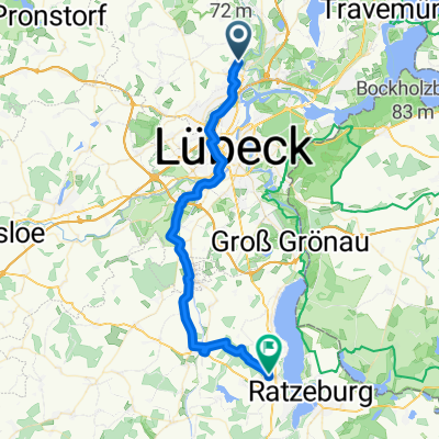
Overview
About this route
The second part of the tour takes us through the Waldhusen Forest, Ovendorf, Warnsdorf, Häven, Niendorf/O. to the destination point Hermannshöhe.
- -:--
- Duration
- 15.1 km
- Distance
- 85 m
- Ascent
- 70 m
- Descent
- ---
- Avg. speed
- ---
- Max. altitude

Route quality
Waytypes & surfaces along the route
Waytypes
Quiet road
7.7 km
(51 %)
Cycleway
2.4 km
(16 %)
Surfaces
Paved
11.3 km
(75 %)
Unpaved
2.7 km
(18 %)
Asphalt
9.7 km
(64 %)
Gravel
2.6 km
(17 %)
Route highlights
Points of interest along the route

Point of interest after 8.7 km
Karls Erdbeerhof
Continue with Bikemap
Use, edit, or download this cycling route
You would like to ride Osterrundfahrt 2.Teil or customize it for your own trip? Here is what you can do with this Bikemap route:
Free features
- Save this route as favorite or in collections
- Copy & plan your own version of this route
- Sync your route with Garmin or Wahoo
Premium features
Free trial for 3 days, or one-time payment. More about Bikemap Premium.
- Navigate this route on iOS & Android
- Export a GPX / KML file of this route
- Create your custom printout (try it for free)
- Download this route for offline navigation
Discover more Premium features.
Get Bikemap PremiumFrom our community
Other popular routes starting in Bad Schwartau
 Radrunde durch Bad Schwartau
- Distance
- 12.3 km
- Ascent
- 24 m
- Descent
- 22 m
- Location
- Bad Schwartau, Schleswig-Holstein, Germany
 1. Etappe - von Bad Schwartau über Krummesse /Berkenthin nach Einhaus
- Distance
- 36.2 km
- Ascent
- 224 m
- Descent
- 242 m
- Location
- Bad Schwartau, Schleswig-Holstein, Germany
 Schleichweg nach Travemünde, hinter Teerhofinsel entlang
- Distance
- 14.2 km
- Ascent
- 117 m
- Descent
- 153 m
- Location
- Bad Schwartau, Schleswig-Holstein, Germany
 RTF - Ostholstein-Rundfahrt 2010 - 86 km
- Distance
- 86.5 km
- Ascent
- 252 m
- Descent
- 252 m
- Location
- Bad Schwartau, Schleswig-Holstein, Germany
 Ostholstein einfach nur schön 😊
- Distance
- 34 km
- Ascent
- 222 m
- Descent
- 226 m
- Location
- Bad Schwartau, Schleswig-Holstein, Germany
 RTF Bad Schwartau 122 km
- Distance
- 121.7 km
- Ascent
- 623 m
- Descent
- 597 m
- Location
- Bad Schwartau, Schleswig-Holstein, Germany
 Aufnahme vom 03.04.2017, 17:40
- Distance
- 11.1 km
- Ascent
- 32 m
- Descent
- 29 m
- Location
- Bad Schwartau, Schleswig-Holstein, Germany
 Osterrundfahrt 2.Teil
- Distance
- 15.1 km
- Ascent
- 85 m
- Descent
- 70 m
- Location
- Bad Schwartau, Schleswig-Holstein, Germany
Open it in the app