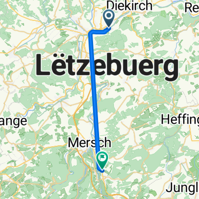
Oesling -Eifel 2
A cycling route starting in Erpeldange, District de Diekirch, Luxembourg.
Overview
About this route
Plenty of elevation gain on both sides of the German-Luxembourg border
- -:--
- Duration
- 150 km
- Distance
- 1,522 m
- Ascent
- 1,523 m
- Descent
- ---
- Avg. speed
- ---
- Max. altitude
Route quality
Waytypes & surfaces along the route
Waytypes
Road
36 km
(24 %)
Quiet road
12 km
(8 %)
Surfaces
Paved
120 km
(80 %)
Unpaved
1.5 km
(1 %)
Asphalt
115.5 km
(77 %)
Paved (undefined)
4.5 km
(3 %)
Continue with Bikemap
Use, edit, or download this cycling route
You would like to ride Oesling -Eifel 2 or customize it for your own trip? Here is what you can do with this Bikemap route:
Free features
- Save this route as favorite or in collections
- Copy & plan your own version of this route
- Split it into stages to create a multi-day tour
- Sync your route with Garmin or Wahoo
Premium features
Free trial for 3 days, or one-time payment. More about Bikemap Premium.
- Navigate this route on iOS & Android
- Export a GPX / KML file of this route
- Create your custom printout (try it for free)
- Download this route for offline navigation
Discover more Premium features.
Get Bikemap PremiumFrom our community
Other popular routes starting in Erpeldange
- Erpeldange - Lipperscheid
- Distance
- 13.5 km
- Ascent
- 600 m
- Descent
- 381 m
- Location
- Erpeldange, District de Diekirch, Luxembourg
- Etape 4 new
- Distance
- 12.5 km
- Ascent
- 459 m
- Descent
- 234 m
- Location
- Erpeldange, District de Diekirch, Luxembourg
- Oesling -Eifel 2
- Distance
- 150 km
- Ascent
- 1,522 m
- Descent
- 1,523 m
- Location
- Erpeldange, District de Diekirch, Luxembourg
- Erpeldange-Reisdorf-Berdorf-Grevenmacher-Echternach
- Distance
- 116.1 km
- Ascent
- 456 m
- Descent
- 449 m
- Location
- Erpeldange, District de Diekirch, Luxembourg
- Ingeldorf-Groensteen-Bourscheid-Warken
- Distance
- 51.8 km
- Ascent
- 784 m
- Descent
- 781 m
- Location
- Erpeldange, District de Diekirch, Luxembourg
- Langsame Fahrt in Erpeldingen
- Distance
- 0.2 km
- Ascent
- 0 m
- Descent
- 0 m
- Location
- Erpeldange, District de Diekirch, Luxembourg
- Roth an der Our
- Distance
- 36.5 km
- Ascent
- 336 m
- Descent
- 335 m
- Location
- Erpeldange, District de Diekirch, Luxembourg
- Etape 4 new bis
- Distance
- 13.7 km
- Ascent
- 602 m
- Descent
- 376 m
- Location
- Erpeldange, District de Diekirch, Luxembourg
Open it in the app