

Wielka Pętla Beskidzka
A cycling route starting in Besko, Subcarpathian Voivodeship, Poland.
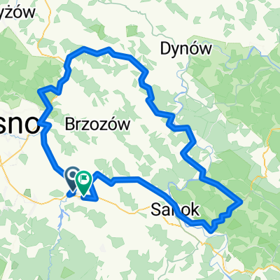
Overview
About this route
Bardzo trudna i żmudna trasa przeznaczona na ok. 12 godzin ciągłej jazdy. Wspaniałe widoki na Połoniny i najwyższe szczyty Bieszczadów. Niesamowita fauna i flora Bieszczadzkiego PN połączona z wyjątkowym klimatem bieszczadzkich zakapiorów gwarantuje wspaniałą zabawę.
- -:--
- Duration
- 213.9 km
- Distance
- 1,269 m
- Ascent
- 1,267 m
- Descent
- ---
- Avg. speed
- ---
- Max. altitude

Route quality
Waytypes & surfaces along the route
Waytypes
Busy road
161.2 km
(75 %)
Access road
13.2 km
(6 %)
Surfaces
Paved
183.9 km
(86 %)
Unpaved
3.3 km
(2 %)
Asphalt
181.8 km
(85 %)
Ground
2.1 km
(1 %)
Continue with Bikemap
Use, edit, or download this cycling route
You would like to ride Wielka Pętla Beskidzka or customize it for your own trip? Here is what you can do with this Bikemap route:
Free features
- Save this route as favorite or in collections
- Copy & plan your own version of this route
- Split it into stages to create a multi-day tour
- Sync your route with Garmin or Wahoo
Premium features
Free trial for 3 days, or one-time payment. More about Bikemap Premium.
- Navigate this route on iOS & Android
- Export a GPX / KML file of this route
- Create your custom printout (try it for free)
- Download this route for offline navigation
Discover more Premium features.
Get Bikemap PremiumFrom our community
Other popular routes starting in Besko
 Besko - Bukowsko - Szczawne Kulaszne - Zagórz - Sanok (pętla)
- Distance
- 79.7 km
- Ascent
- 570 m
- Descent
- 570 m
- Location
- Besko, Subcarpathian Voivodeship, Poland
 Wielka Pętla Beskidzka
- Distance
- 213.9 km
- Ascent
- 1,269 m
- Descent
- 1,267 m
- Location
- Besko, Subcarpathian Voivodeship, Poland
 Besko - Sanok - Bukowsko
- Distance
- 29.3 km
- Ascent
- 164 m
- Descent
- 60 m
- Location
- Besko, Subcarpathian Voivodeship, Poland
 Besko - Iskrzynia - Domaradz - Brzozów - Turze Pole - Wzdów - Besko
- Distance
- 64.4 km
- Ascent
- 391 m
- Descent
- 389 m
- Location
- Besko, Subcarpathian Voivodeship, Poland
 Magurski Park Narodowy
- Distance
- 141.2 km
- Ascent
- 1,065 m
- Descent
- 1,065 m
- Location
- Besko, Subcarpathian Voivodeship, Poland
 Besko - Bukowsko - Komańcza - Jaśliska - Besko
- Distance
- 96.9 km
- Ascent
- 636 m
- Descent
- 636 m
- Location
- Besko, Subcarpathian Voivodeship, Poland
 Bardzo góra Bukowica
- Distance
- 105 km
- Ascent
- 834 m
- Descent
- 832 m
- Location
- Besko, Subcarpathian Voivodeship, Poland
 Dróżka na około
- Distance
- 137.2 km
- Ascent
- 945 m
- Descent
- 950 m
- Location
- Besko, Subcarpathian Voivodeship, Poland
Open it in the app