

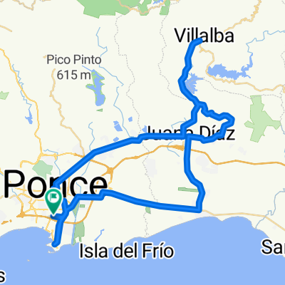
Ruta: Ponce-Collores-Villalba-Ponce
A cycling route starting in Ponce, Ponce Municipio, Puerto Rico.
Overview
About this route
ROUTE: Ponce-Collores- Villalba-Juana Díaz-Ponce Start point:Med Centro, Ponce Farthest Point:Downtown Villalba End Point:Med Centro, Ponce Distance:34mi/55km Total Time:3:30 hr Moving Time:2:40 hr Avg Moving Speed:13 mph Elevation Gain:1,750 ft Calories:1,600 to 2,000
ROUTE DESCRIPTION: This is a good route for avid cyclists who are not necessarily aiming to do competitive cycling. First 10 miles are comprised by flat and mild hills. Following 4 miles are is a more steep climbing to the highest point of the route, followed by a2 mile descent. The rest is a hilly roller coaster throughout the route. Last 5 miles is a very moderate descent passing through downtown Ponce until the End Point. Route is all paved and is suitable for either MTB or Road bikes. However, be aware that roads may have unknown damaged pave at times. This is a very enjoyable route throughout countryside PR. Cyclists moderately trained should be able to complete it with ease. Great to be done with pals and share a great time together.
- -:--
- Duration
- 55.2 km
- Distance
- 388 m
- Ascent
- 386 m
- Descent
- ---
- Avg. speed
- ---
- Max. altitude
Route quality
Waytypes & surfaces along the route
Waytypes
Road
26.6 km
(48 %)
Busy road
22.5 km
(41 %)
Surfaces
Paved
4.1 km
(7 %)
Asphalt
4.1 km
(7 %)
Undefined
51.2 km
(93 %)
Continue with Bikemap
Use, edit, or download this cycling route
You would like to ride Ruta: Ponce-Collores-Villalba-Ponce or customize it for your own trip? Here is what you can do with this Bikemap route:
Free features
- Save this route as favorite or in collections
- Copy & plan your own version of this route
- Sync your route with Garmin or Wahoo
Premium features
Free trial for 3 days, or one-time payment. More about Bikemap Premium.
- Navigate this route on iOS & Android
- Export a GPX / KML file of this route
- Create your custom printout (try it for free)
- Download this route for offline navigation
Discover more Premium features.
Get Bikemap PremiumFrom our community
Other popular routes starting in Ponce
 MBR 2014 - Larga Road Bike (Ruta B)
- Distance
- 86.9 km
- Ascent
- 459 m
- Descent
- 459 m
- Location
- Ponce, Ponce Municipio, Puerto Rico
 MED BIKE RALLY LONG ROUTE STREET BIKE
- Distance
- 69.7 km
- Ascent
- 434 m
- Descent
- 434 m
- Location
- Ponce, Ponce Municipio, Puerto Rico
 Med Centro-Collores-Villaba-JDiaz-Med Centro
- Distance
- 55.2 km
- Ascent
- 393 m
- Descent
- 390 m
- Location
- Ponce, Ponce Municipio, Puerto Rico
 Martes De Bicicleta
- Distance
- 13.4 km
- Ascent
- 22 m
- Descent
- 21 m
- Location
- Ponce, Ponce Municipio, Puerto Rico
 MBR - Ruta Larga - 50M-80K
- Distance
- 79.5 km
- Ascent
- 418 m
- Descent
- 417 m
- Location
- Ponce, Ponce Municipio, Puerto Rico
 MED BIKE RALLY LONG RUTE MOUNTAIN BIKE ROUTE
- Distance
- 76.5 km
- Ascent
- 420 m
- Descent
- 420 m
- Location
- Ponce, Ponce Municipio, Puerto Rico
 Light Workout
- Distance
- 4.7 km
- Ascent
- 25 m
- Descent
- 26 m
- Location
- Ponce, Ponce Municipio, Puerto Rico
 Ruta: Ponce-Collores-Villalba-Ponce
- Distance
- 55.2 km
- Ascent
- 388 m
- Descent
- 386 m
- Location
- Ponce, Ponce Municipio, Puerto Rico
Open it in the app