

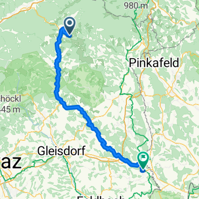
Ratten - Fürstenfeld
A cycling route starting in Sankt Jakob im Walde, Styria, Austria.
Overview
About this route
Pfingstradtour 2014
Von Feistriztal zum Lafnitztal- -:--
- Duration
- 88.4 km
- Distance
- 178 m
- Ascent
- 882 m
- Descent
- ---
- Avg. speed
- ---
- Max. altitude

Route quality
Waytypes & surfaces along the route
Waytypes
Quiet road
24.5 km
(28 %)
Cycleway
22.3 km
(25 %)
Surfaces
Paved
46.1 km
(52 %)
Unpaved
9.7 km
(11 %)
Asphalt
43.5 km
(49 %)
Gravel
7.7 km
(9 %)
Continue with Bikemap
Use, edit, or download this cycling route
You would like to ride Ratten - Fürstenfeld or customize it for your own trip? Here is what you can do with this Bikemap route:
Free features
- Save this route as favorite or in collections
- Copy & plan your own version of this route
- Split it into stages to create a multi-day tour
- Sync your route with Garmin or Wahoo
Premium features
Free trial for 3 days, or one-time payment. More about Bikemap Premium.
- Navigate this route on iOS & Android
- Export a GPX / KML file of this route
- Create your custom printout (try it for free)
- Download this route for offline navigation
Discover more Premium features.
Get Bikemap PremiumFrom our community
Other popular routes starting in Sankt Jakob im Walde
 Bergstrecke in St. Jakob im Walde
- Distance
- 14.3 km
- Ascent
- 555 m
- Descent
- 554 m
- Location
- Sankt Jakob im Walde, Styria, Austria
 Pittermann 78 nach Pittermann 78
- Distance
- 23.7 km
- Ascent
- 660 m
- Descent
- 660 m
- Location
- Sankt Jakob im Walde, Styria, Austria
 Wildwiesenrunde
- Distance
- 24.1 km
- Ascent
- 587 m
- Descent
- 588 m
- Location
- Sankt Jakob im Walde, Styria, Austria
 bucklige welt runde
- Distance
- 72.9 km
- Ascent
- 2,054 m
- Descent
- 2,052 m
- Location
- Sankt Jakob im Walde, Styria, Austria
 St. Jakob Pöllauberg
- Distance
- 94.6 km
- Ascent
- 1,872 m
- Descent
- 2,109 m
- Location
- Sankt Jakob im Walde, Styria, Austria
 Ratten - Fürstenfeld
- Distance
- 88.4 km
- Ascent
- 178 m
- Descent
- 882 m
- Location
- Sankt Jakob im Walde, Styria, Austria
 St. Jakob Pöllauberg CLONED FROM ROUTE 400253
- Distance
- 94.7 km
- Ascent
- 1,544 m
- Descent
- 1,557 m
- Location
- Sankt Jakob im Walde, Styria, Austria
 FamilyBike Wadlzwicker Runde
- Distance
- 12 km
- Ascent
- 219 m
- Descent
- 219 m
- Location
- Sankt Jakob im Walde, Styria, Austria
Open it in the app